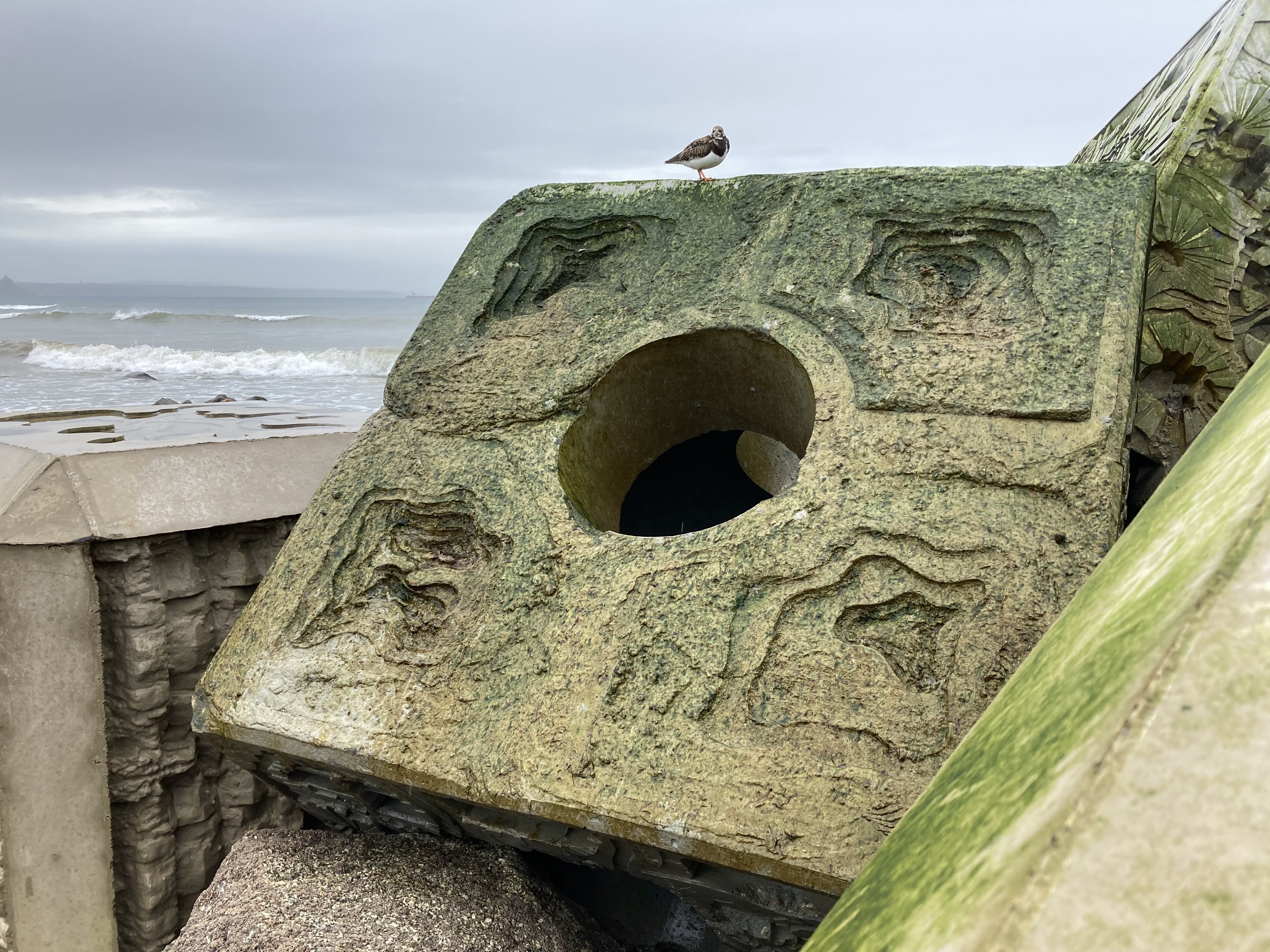
Close X
 SARCC
SARCC
Reset View
Pilot Areas
Themes
Tools
Help


The academic partners with SARCC project conceptualized and developed the methodology Nature-Inclusive Urban-Coastal Management- Framework (NUM). This is a Project Guide for the Implementation and Monitoring of Nature Based Solutions (NBS) to create Climate Resilient Coastal Cities. It is specially developed for professionals working in the field of urban (coastal) developments in municipalities and consultancy offices to support the inclusion of nature as a way of coastal protection. The NUM charts the development process from initiation to construction, maintenance and feedback.
Each of the proposed NBS within the pilot sites were constructed despite constraints brought about by the Covid pandemic, albeit that the time scale of the SARCC project meant that monitoring is in its early stages. Accordingly, this section of the visualisation tool presents a quick and easy to use demonstration of the Project Design Development Framework (PDDF), which is an instrument within the NUM that steps through the initial phases of the proposed coastal development to the final design that ultimately resulted in construction. Examples are provided from the various pilot sites to demonstrate the different phases of the PDDF. This includes the planned benefits of the NBS, where sufficient empirical data has been gathered for the outcomes of pilots to be quantified. For more detail for all the pilot and case study sites, see the Guidance Booklets here and the Urban-Coastal Mangagement-Framework here.
The six key stages of the PDDF are punctuated with cross-sectoral dialogue through stakeholder workshops that explain the synergies between stages and elements of the Framework. Click the image below to view a larger version.
Find out more:
Video (Dutch): An Introduction to SARCC (Bert Van Severen)
Video (Dutch): Climate change and the future potential impact (Patrick Meire)
Video (English): Workshop Funding for NBS – session one
Video (English): Workshop Funding for NBS – session two
Presentation (Dutch): Seminar ‘Natuurlijk! Ruimtelijke ontwikkeling van onze Noordzeekust’
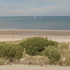
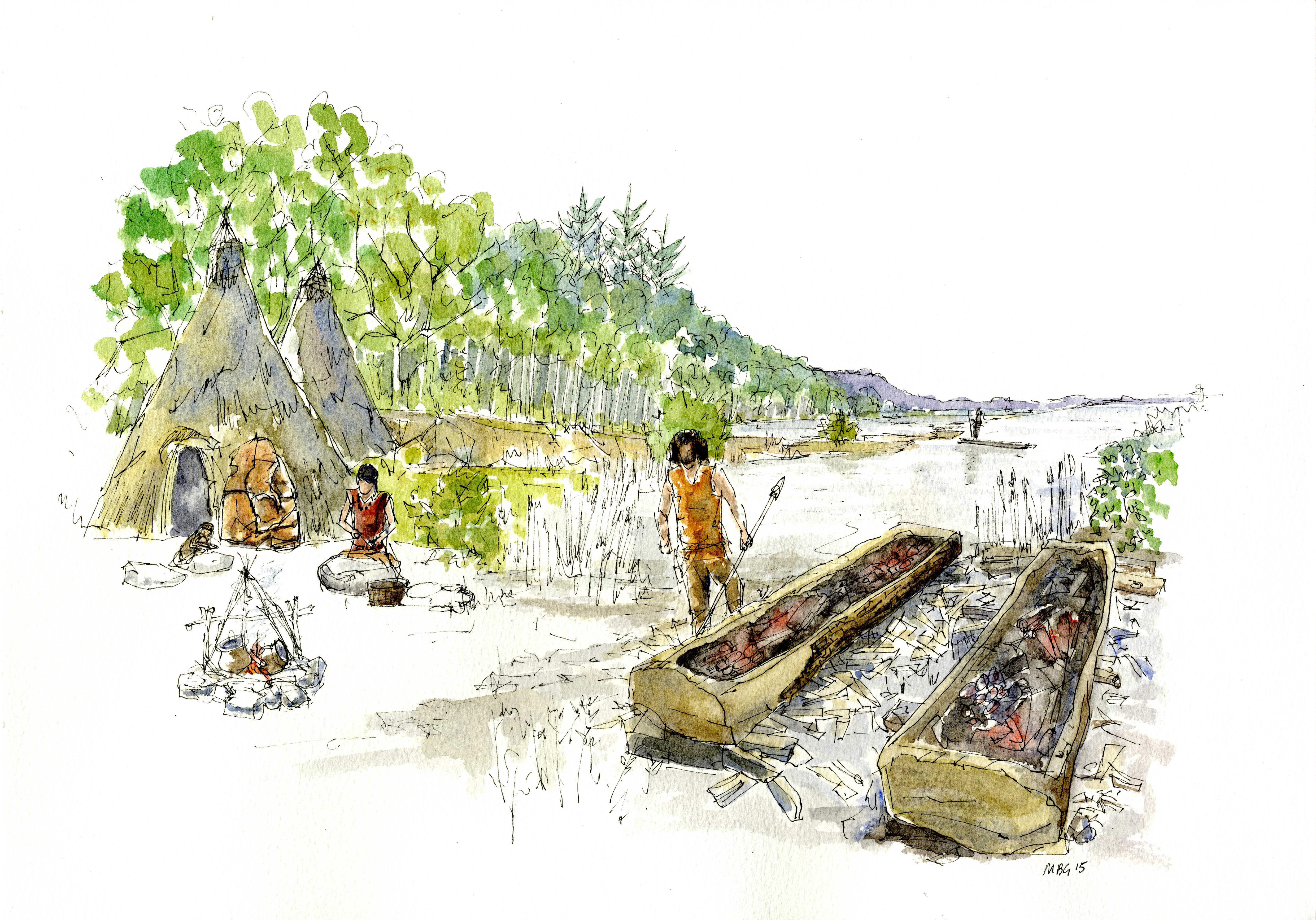
The longue durée, or the ‘long view’, provides a historical context to the current coastline through the charting of its natural and anthropological evolution. The patterns of change over time can provide valuable information for urban coastal planners.
The project shows how an assessment of the Longue Durée provides an understanding of causal mechanisms that have shaped the coastline. Where these processes are identified as ongoing, this can inform coastal managers about the long-term forces acting on the coastline and contribute to a positive decision-making process. This provides historically derived baseline data that can be firmly integrated into the Project Design Development Framework.
The initial stage is to build ‘Atlases’ that bring together datasets for analysis. The Maritime Atlas includes artistic, cartographic, photographic, archaeological, and geomorphological data. The strategy has the added benefit of recovering representations from historical documents and artworks can be a very valuable tool when telling the story of the transient nature of a coastline to the public.
Maritime
Atlas
Purpose: to evaluate the geomorphological processes and how humans interacted and intervened with
the coastal
landscape over time.
Archaeological Indicator Example: Western Solent, UK
The area of the Western Solent on the South Coast of the UK is a case study that has been selected
as an analogue for the pilot sites. It is a perfect example of the fluctuating relationship
between land and sea across millennia. Early archaeological material indicting coastal change has
come from the Mesolithic site of Bouldnor Cliff that dates to the period 8,000 years ago. This was
before Britain was separated from mainland Europe. Further sites covering most periods up until
modern times provide temporal continuity for thousands of years. An increase in erosion is now
exposing the landscapes within which the archaeology sits indicating coastal change. The
archaeological record shows how people adapted to change in the past and how the changing climate
and human actions have put the coastline under threat.
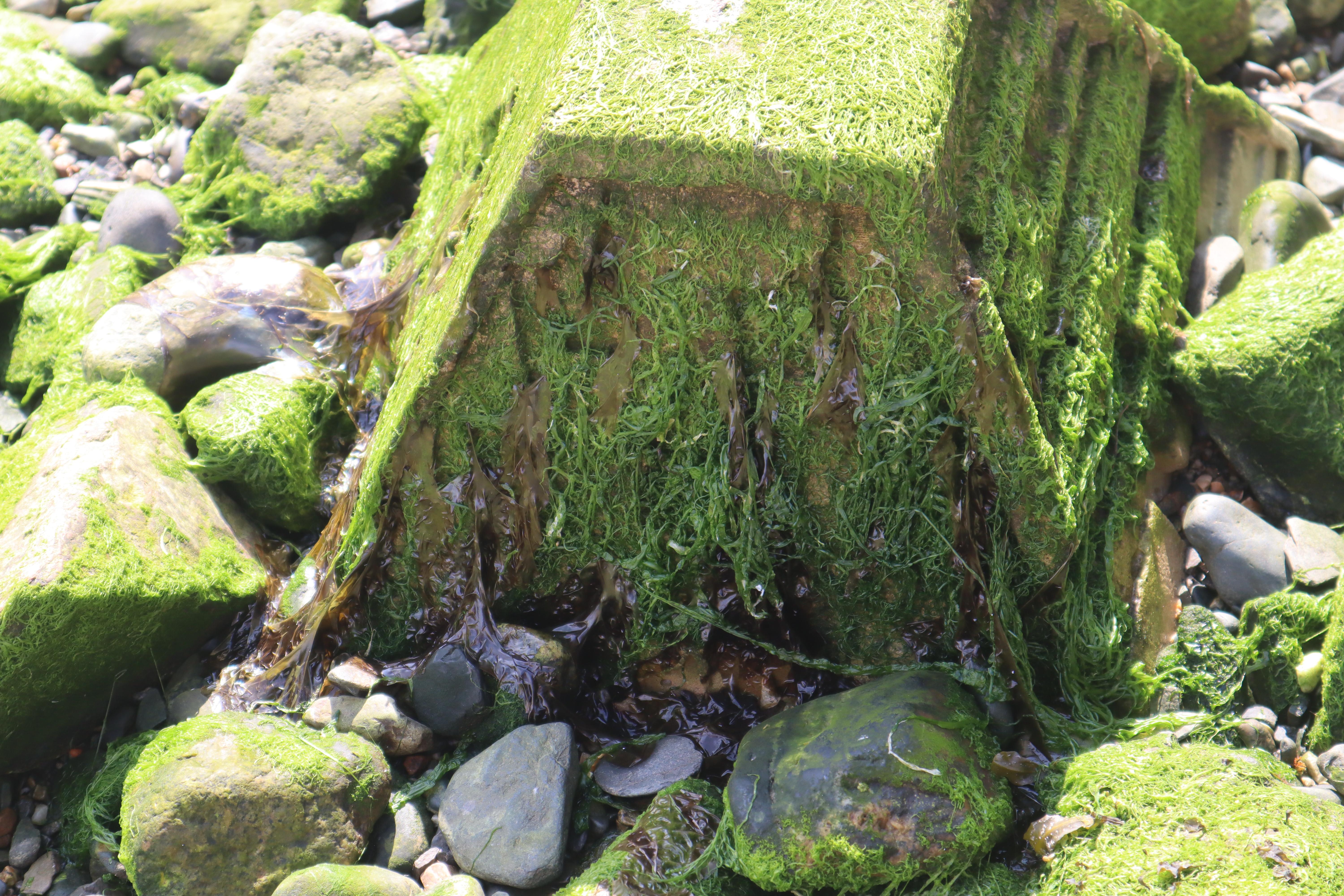
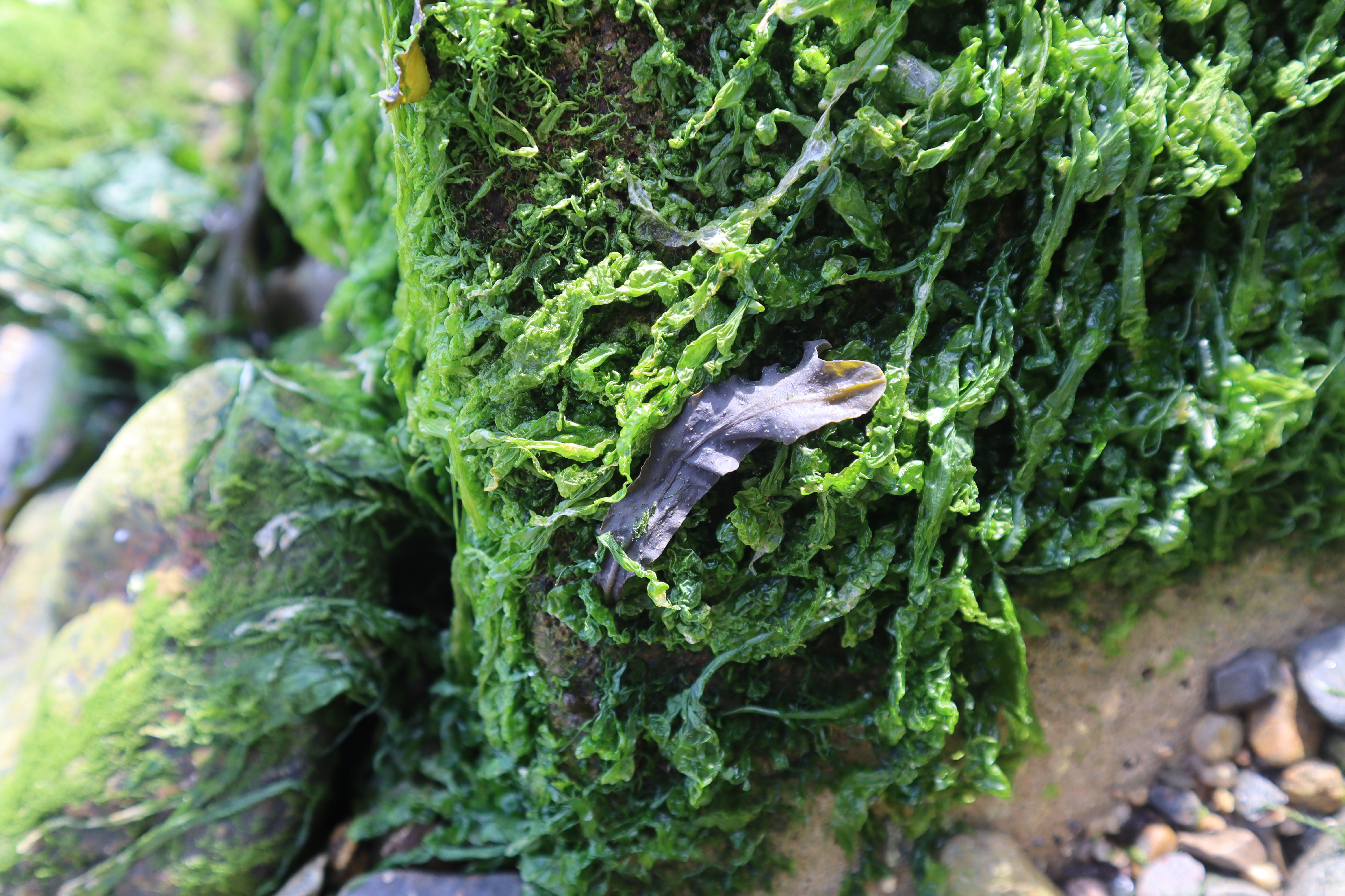
Remains of prehistoric forest in the intertidal zone.
Remains of a Bronze Age fish trap.
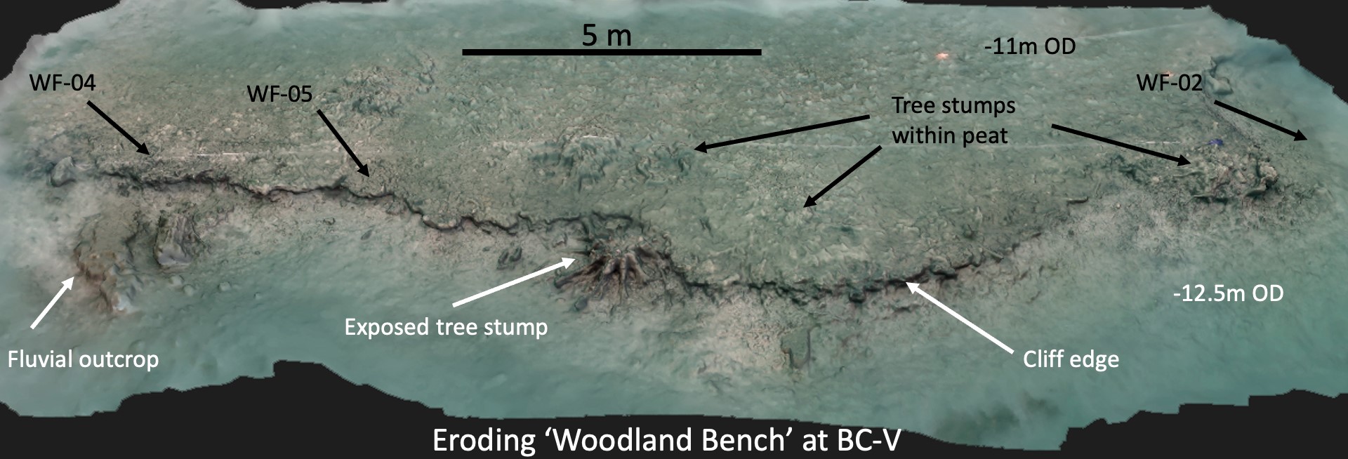
The underwater Mesolithic site of Bouldnor Cliff.
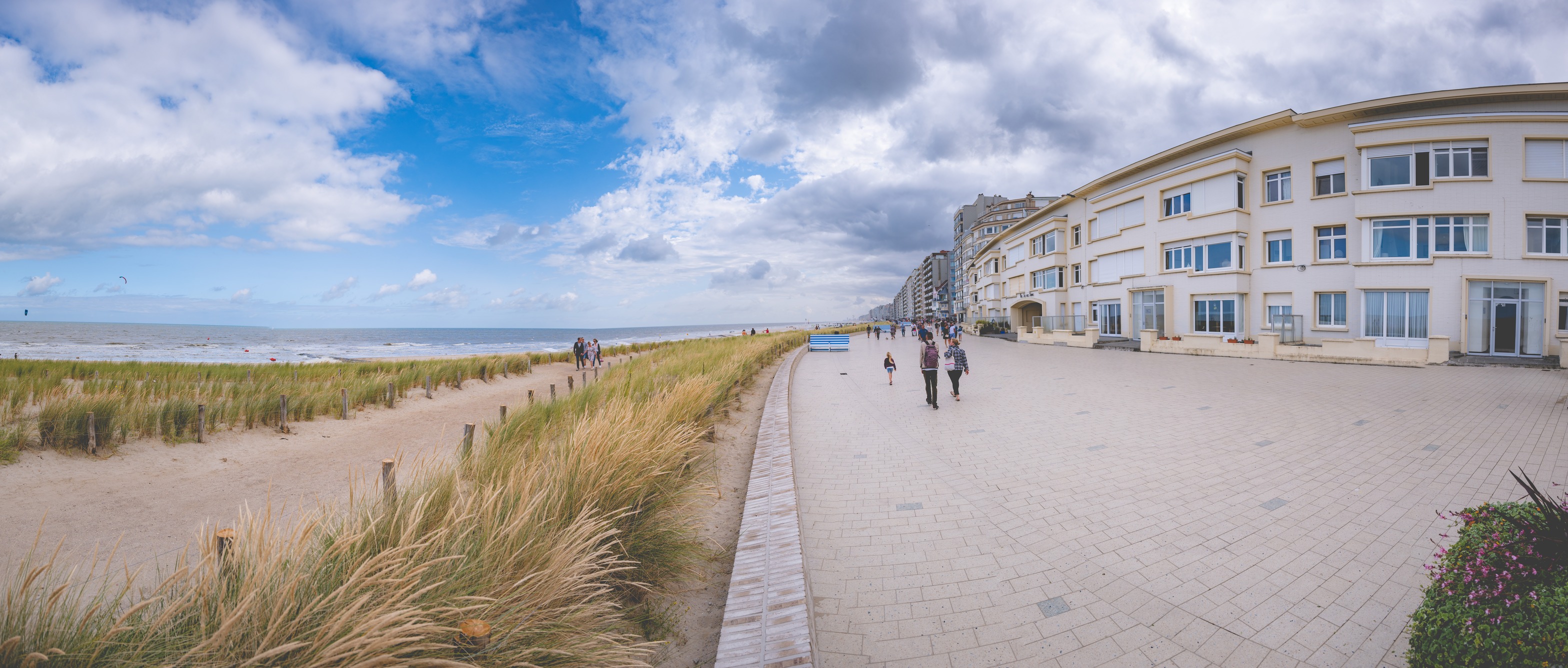
Maps and Charts Indicator Example: Belgian Coast
Historical maps and charts are a key indicator of patterns of change over time: they show not only
the morphology of the coastline, but patterns of urbanisation and land usage. Longstanding
structures or buildings can be used as reference points on a map and data such as the etymology of
place names can be analysed to relate their relationship to the landscape.
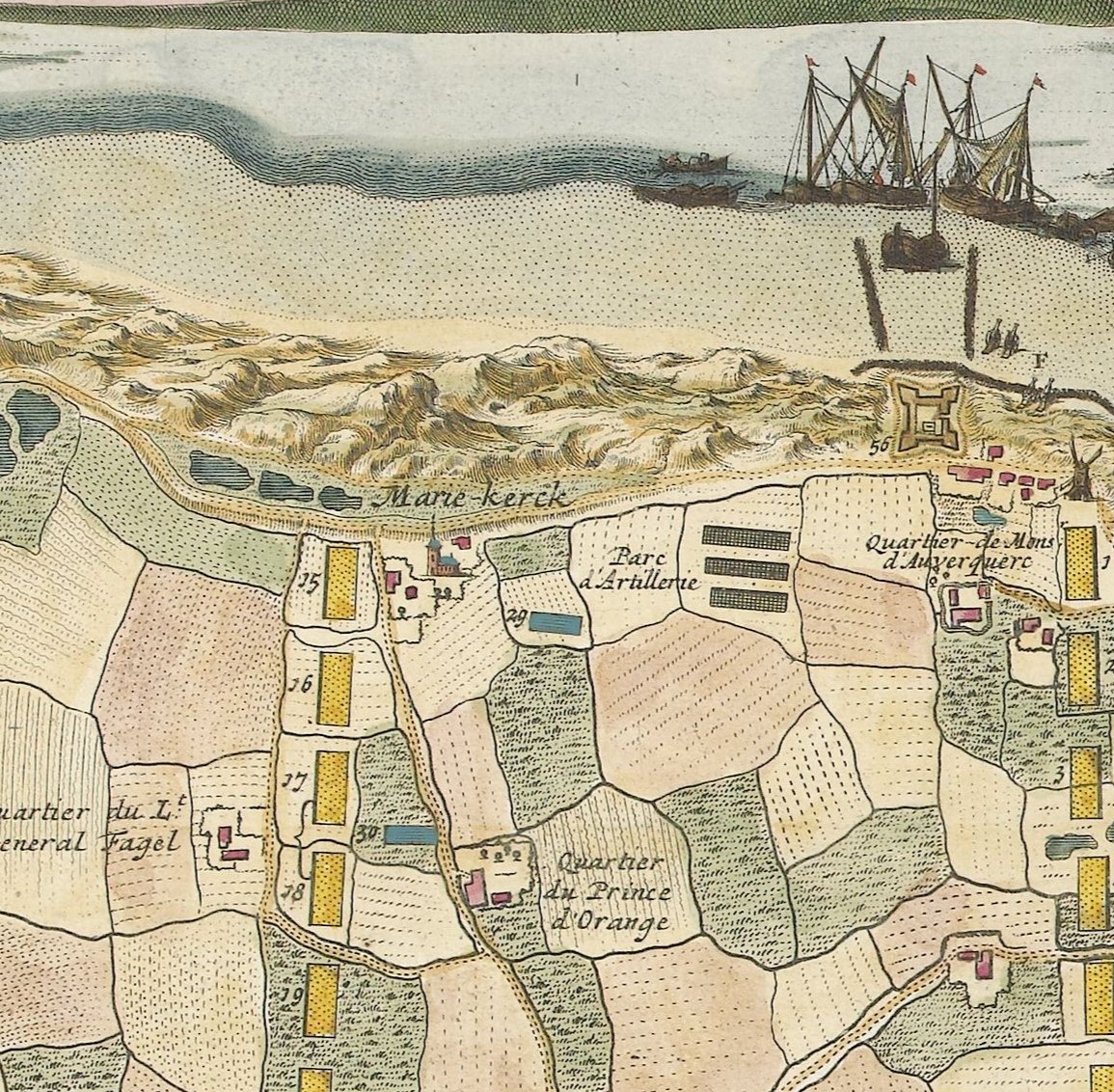
Dunes to the West of Oostende - 1706.
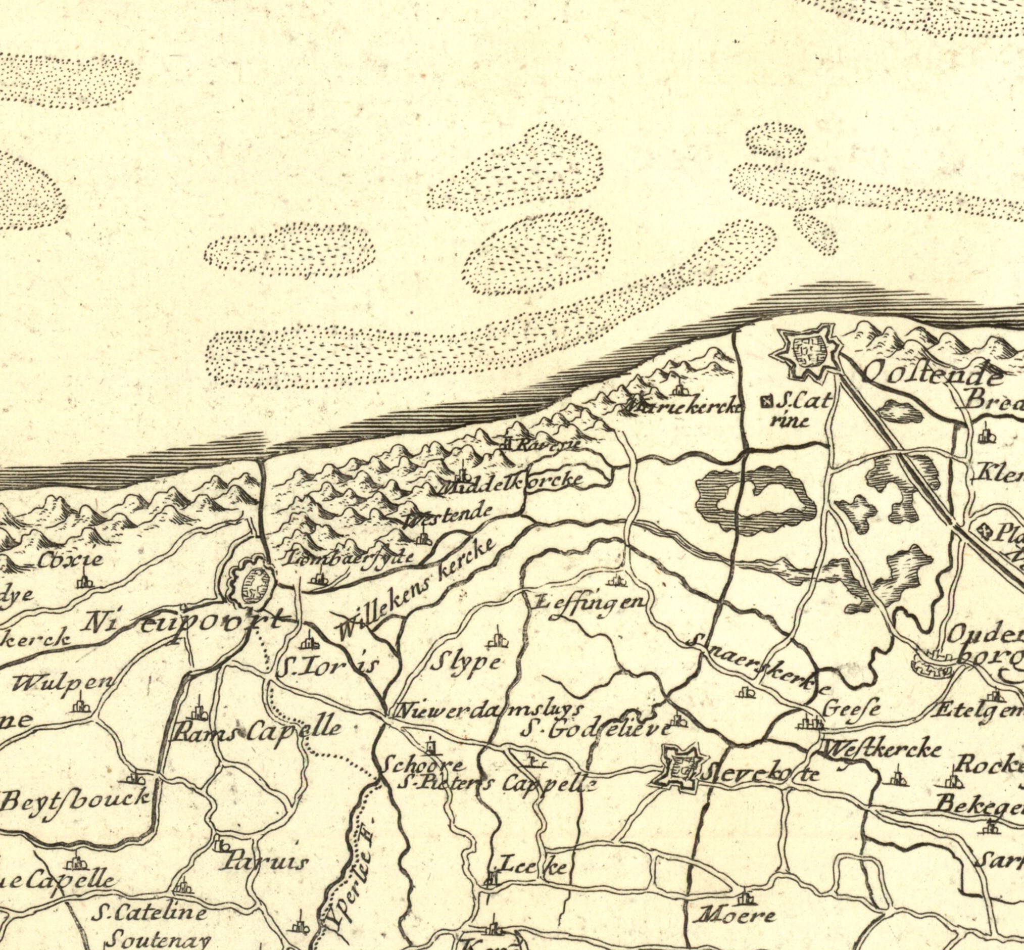
The Belgian Coast, 1697, showing dunes.
Art Indicator Example: Belgian Coast
The Belgian Coast has been the subject of many works of art throughout history – works which can
be used to document how the coastline and urban areas have changed over time. These images show
the dune systems around Blankenberge and demonstrate that this was the natural state of the
coastline before modern development. Coupled with the other data sources, we can demonstrate the
effectiveness of dune systems as a nature-based solutions for much of history.
Dunes to the West of Oostende - 1706.
The Belgian Coast, 1697, showing dunes.
Images Indicator Example: Vlissingen, the Netherlands, and Southend-On-Sea, UK
Though photography has not been around as long as the ability to create paintings, they are still
exceptionally useful in documenting more recent changes. Images of flooding along the Flemmish
coast and at Vlissingen capture the impact on coastal towns while at Southend-on-Sea, photographs
show the eroding cliff lines and changing shape of the beach. When compared to modern data, these
highlight particularly vulnerable areas.
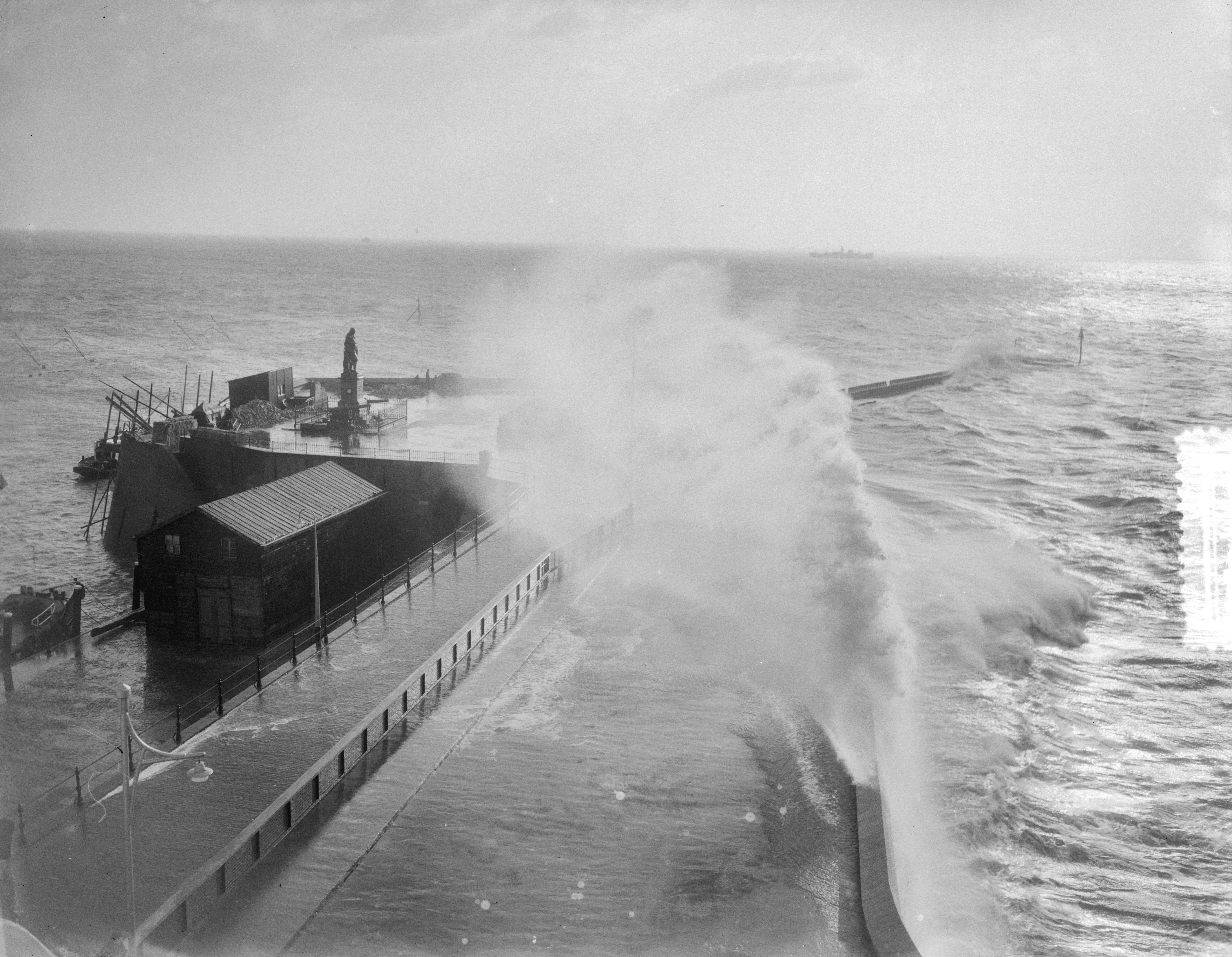
Storm in Vlissingen, 1954.
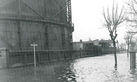
Flooded Gas Works in Southend-on-Sea, 1953
Landscape Atlas
Purpose: used
to evaluate the landscape (soil and water), and urban morphology and infrastructure (historical
dikes) on the regional scale.
Landscape Atlas Example: Vlissingen, the Netherlands
Vlissingen is a good example of a coastal Dutch town with an old centre within a citadel. On the
east side there is a large industrial area, port and channel to the Veerse Meer. It is situated on
a former island - Walcheren – which, by reclaiming land, has become a peninsula with the former
island Zuid Beveland, connected to the mainland. It is encircled by a large dike, the inlands are
polders that are drained by pumps 24/7. By looking at the landscape beyond the city itself, we can
gather a wider view of the impact of both coastal change and potential solutions.
Planning Atlas
Purpose: using
the Historical Assessment of Planning Policies to understand the past decision-making process, and
the impact of the policies on spatial factors of coastline defence. Historical maps and charts can
show where development of urban planning through time has impacted on the coastal landscape and
interfered with natural processes.
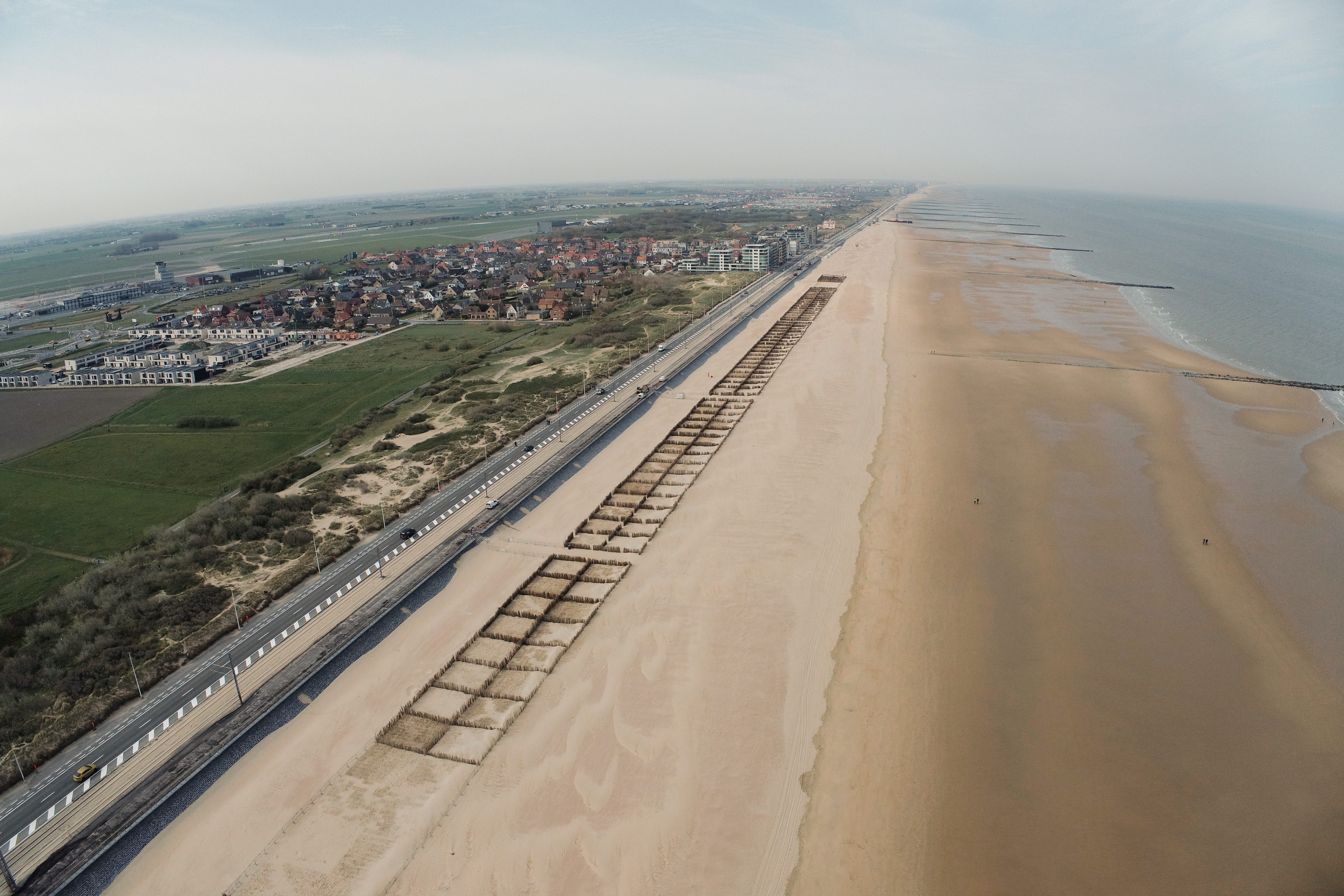
Planning Atlas Example: Oostende, the Netherlands
The Flemish coastline is now defended by dikes but this has disrupted the natural adaptability of
the old dune systems to provide protection. In Oostende and associated towns, the has resulted in
a policy of beach nourishment, bringing sand from offshore. This is expensive and relentless
challenge as the storms then removes the sand. This is arguably a natural solution but without a
long term understanding of the coastal process that created equilibriums’ when the sand was in
balance with the forces over thousands of years. This method of artificial replenishment has other
drawbacks: it can seriously disrupt marine life, drain finite sand reserves, and also create
‘minor inconveniences’. The sand in Oostende blows over the dike, particularly in
Raversijde-Mariakerke, just west of Ostend’s city centre. Here, the Koninklijke Baan, the Coast
Tram and the cycle path run on the dike, right up against the beach. The costs related to the
obstructed traffic and the clearance work can run up quickly. On top of that, the cleared sand
cannot simply be thrown back onto the beach because it might be contaminated by traffic. It is
then disposed of as “waste” and processed.
Find out more:
Presentation (Dutch): Oorlogsrelicten in de duinen: puin of erfgoed? (Mathieu Demeyer, Wouter Gheyle, Sam De Decker)
Presentation (Dutch): Uitdagingen voor de biodiversiteit in de duinen (Sam Provoost)
Video (Dutch): Coastal morphology, then and now / Morfologie van de kustlijn: vroeger en nu? (Maxime Poulin and Pieter Rauwoens )
Video (English): Workshop Methodology behind NBS strategies business cases – session one
Video (English): Workshop Methodology behind NBS strategies business cases – session two
Video (English): Coastal change through historic trend analysis (Garry Momber)
The longue durée is the process that provides the baseline for the contemporary urban landscape. In cities, it identifies the artificial terrain that has created barriers to the natural drainage, causing ‘weak’ spots, which need to be identified in order to assess their potential impact on the urban environment. In order to qualify and quantify these impacts, flood and urban atlases need to be integrated with the longue durée.
Flood
Atlas
The Flood Atlas assesses the land and seascape to identifies the risks of fluvial and marine
flooding. Within the SARCC project TU Delft used bathymetry, inlet boundary conditions, and
coastal roughness to feed into numerical simulations (Delft3d) to test spatial solutions. Further
methodological details can be found here.
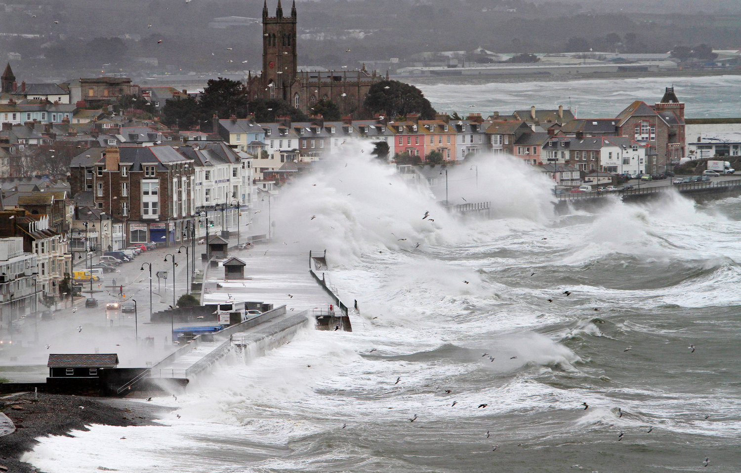
Flood Atlas Example: Southend-on-Sea, UK
In Southend on Sea both water run off during storm events and marine storm surges have to be taken
into account. Currently, the entire sea front is protected by hard defence structures including
revetments, sea walls, and groynes to mitigate wave impact. Today, in coherence with the Thames
Estuary action plan for 2100, the Southend on Sea Borough Council is promoting rebuilding and
refurbishment works of the defences as they come to the end of their lifespan. Reinforcing the
defence line is of concern as it may affect the link with the sea of fluvial runoff, therefore
both elements should be assessed, as presented in the following figures, and taken into
consideration. (Click images to expand)
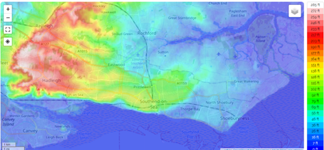
Topography showing the vulnerability to coastal flooding.
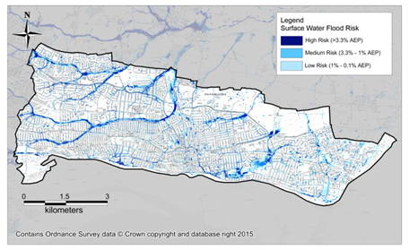
Map showing the surface water flood risk, or pluvial flood risk.
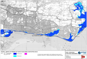
Flood risk from overtopping in 2010.
Flood risk from overtopping in 2100.
Flood Atlas Example: Vlissingen,
The Netherlands
In the Netherlands, marine storm surges are of particular concern. Dutch protection standards
implemented in the Delta Works after the disaster of 1953 have led to protection levels along the
coast, and specifically Zeeland, to resist storms that can be present every 10,000 years. The
Hydra-NL model is a probabilistic model that calculates the statistics of the hydraulic loads
(water level, wave conditions, wave overtopping) for the assessment of the primary dikes and
structures in the Netherlands. A digital surface model (DSM) and a digital elevation model (DTM)
have been generated for the area: the first includes buildings, cars, and trees (following the
surfaces of the shapes present in the city), and the second one follows what should be the
terrain/ground elevation. In the case of Vlissingen, a special manual filtering was applied for
the trees and the cars, especially at the De Spuikom area. Finally, the bathymetry was built, the
results indicated the primary streets by which water can divert to De Spuikom, and what areas are
protected.
The consequences of underestimating the flood risk can end in disaster as historical etchings and
postcards testify.
Artwork of the flood of 15 January 1808.
Storm waves crashing over the Vlissingen Boulevard.
Animation shows Hydrodynamic simulation of Urban flooding of city center of Vlissingen (left: 30 min event and left: 5.5 hr event) (click image to view in new tab)
Urban Atlas
The creation of an Urban Atlas is a
process that maps the heritage of the project area alongside the urban construction and infrastructure systems
(water, energy, civil construction and ecology) against expected urban trends.
Urban Atlas Example: Southend-On-Sea, UK
Southend is one of the most densely populated areas (181,800 inhabitants) outside London. It is located on the mouth
of the River Thames and served by a capillary transport network which includes multiple train stations; its
waterfront has been, historically, an important leisure and recreational area. The urban structure is of sprawl-type
dominated by single-family houses with gardens, whereas public and commercial services are concentrated along
several high streets and recreational grounds (e.g. sport fields). Property development pressure is strong,
particularly along the seafront due to its high economic value.
From a geomorphological perspective, the municipality is divided into two parts: the town centre and western part are located on high ground, while much of the sea front and the eastern part is on lowland at flood risk from the sea. However, due to soil sealing, the risk of pluvial flooding is also common along upland waterways.
The urban evolution of Southend-On-Sea (source: Junzhong, 2019). Click to expand.
Urban Atlas Example: Vlissingen, the Netherlands
In the Netherlands, there is a well-developed process that was applied to the Vlissingen pilot. The System Exploration, Environment and Sub-surface (SEES) stems from the Dutch Layers approach and has six functional layers with different dynamics, professionals and knowledge fields: people, metabolism, occupation, public space, infrastructure and subsurface. SEES connects the subsurface information, urban construction of the area, with the urban surface in order to inspire and set clear boundaries for the development of the urban surface. This process is used for analysing potential problems and should be applied to the design of urban development projects.
a) subsurface, sewer network and potential soil infiltration. Click to expand.
b) intensity of vegetation cover (darker = more intense). Click to expand.
c) roads and dikes (in black). Click to expand.
d) terrain levels (darker = deeper). Click to expand.
Urban Atlas Example: Newlyn, UK
Newlyn has a highly developed and historic coastal frontage, with a fishing port, residential houses and numerous commercial businesses. The community has always been exposed to storms but has experienced increasingly frequent sea flooding and coastal erosion in recent decades. The town is built right on the water’s edge and during heavy storms the waves overtop the breakwater, before propagating into the mouth of the Newlyn Coombe river. Houses, businesses and infrastructure situated at the mouth of the Newlyn Coombe are therefore particularly impacted by the resulting over-topping which occurs. To protect the town from the increasing risk of wave overtopping, this breakwater needs to be reinforced, raised and extended.

Storm waves in Penzance, UK.
Find out more:
Video (Dutch): Flemish coastal protection and NBS pilot projects in Flanders (Peter Van Besien)
Video (Dutch): Sustainability of beach nourishment (Elias Vanquickelborne)
Video (Dutch): Applications of NBS on our sandy coastline (Pieter Rauwoens)
Video (English): Contributions to changing UK coastal flood risk (Tom Howard, Met Office, Hadley Centre)
Video (French): Can nature help us against sea flooding. Comparison of national NBS strategies along the North Sea
Video (Dutch): The changing water system / Het veranderende watersysteem (Patrick Willems and Patrick Meire)
Once the baseline data has been gathered and the challenges to the potential impacts of sea level rise and climate change have been identified, the next step is to establish a vision that incorporates nature-based solutions into the protection of the area that can then be shared with stakeholders.
Vision: Vlissingen, the Netherlands
Ahead of any sea level rise, the preferred option was to incorporate a more natural solution rather than a continual rise in the concrete walled sea defence. An option to adapt the urban landscape and environment was preferred.
The solution proposed was to accept water over the dike during the greatest storms. The water would then be channelled down an enhanced road that would take the water to the relict Spuikom that was once a water reservoir that would fill at high tide and store water that was used to flush out the old harbour at low water.
The ‘Spuikom Model’ incorporates an overtopping sump area. Today, the Spuikom and its surrounding are the focus of a long-term vision by the municipality that aims to transform it into a mixed-use urban development (with commercial, residential, and leisure functions) serving also as a water retention basin (or “overtopping sump”) during any such exceptional flood events.
.jpg)
Overtopping sump model. Click to enlarge (opens in new tab).
Vision: Middelkerke, Belgium
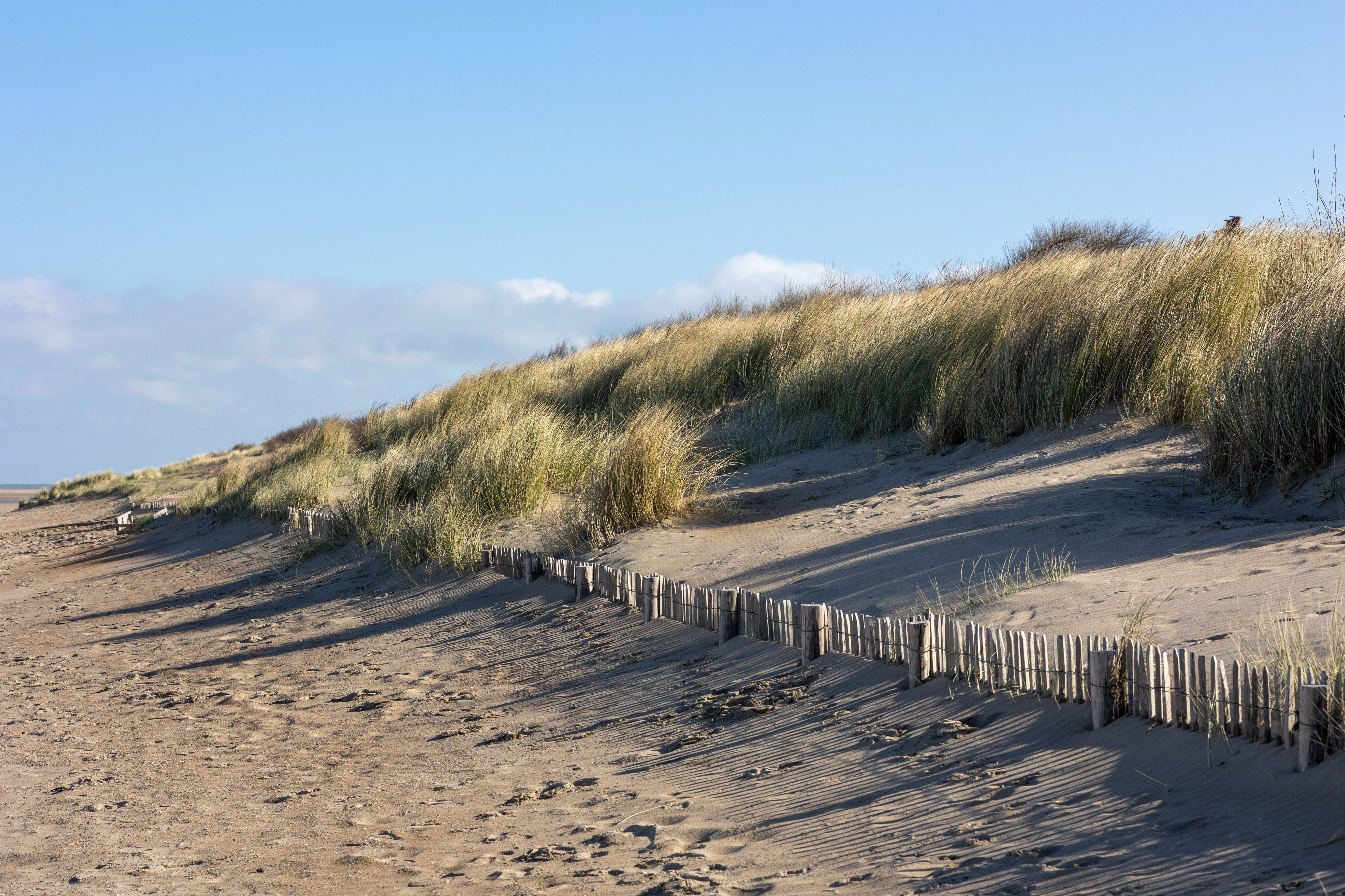
Natural dunes systems can form a natural and solid sea defence. Where a dike is already present for example, in seaside towns a dune seaward of the sea wall can provide additional protection against floods and waves. These new dunes also provide a large sand storage area that protects beach and foreshore from erosion. In an ideal scenario, the dune ensures that the dike does not need to be raised. In addition, the dune-before-dike principle is beneficial to biodiversity and can also add value in terms of tourism.
In Middelkerke the Dune-before-dike was envisioned to take the form of a lowered promenade between the existing sea wall and the beach. On the beach side, the lowered boardwalk will have a wide breaking element that also serves as a rampart. When the water breaks during storm surges, it is collected in the lowered zone and flows back to the sea through openings at the bottom of the breaking element. In total, a 500m long stretch of grass dike was proposed as the pilot project within SARCC.
(170x240)Spreads.jpg)
The 'Dune-before-dike' model. Click to englarge (opens in a new tab).
Vision: Oostende, Belgium
At Oostend a different approach was taken from Middlekerke where an embryonic dune formation is initiated, after which natural processes take over. Thanks to marine sedimentation (sand supplied by tides and waves), aeolian sedimentation (sand supplied by the wind) and the planting of marram grass (which retains the sand), the dune should grow by itself. Indeed, dunes are ‘living dunes’. In a natural situation, dunes can emerge, grow and recover by themselves. Marram grass plays a crucial role in this: marram grass has a densely branched and deep system of rhizomes with which it can keep up with an annual sand growth of 1 m. In other words, marram grass is able to grow with the shifting of sand.
(170x240)Spreads.jpg)
Monitoring dune height in Oostende. Click to enlarge (opens in new tab).
Vision: Blankenberge, Belgium
Blankenberge conceived the plan to dismantle, one lane of the Koninklijke Baan over a length of 700m and return it to nature. At that spot, between the Koninklijke Baan and the beach, there is an elongated and valuable dune area with dune lakes and wet dune grasslands. Plans are to break up an 11 m wide strip (6,700 m2 of road surface would be depavaed, the footpath, cycle path, parking lane, two driving lanes and another parking lane) so all that remains is a recreational cycle path, surrounded by embryonic dune formation. This will create a dune-before-dike widening the existing dune foot over a distance of 700m with the dune growing inland.
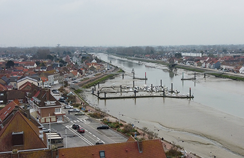
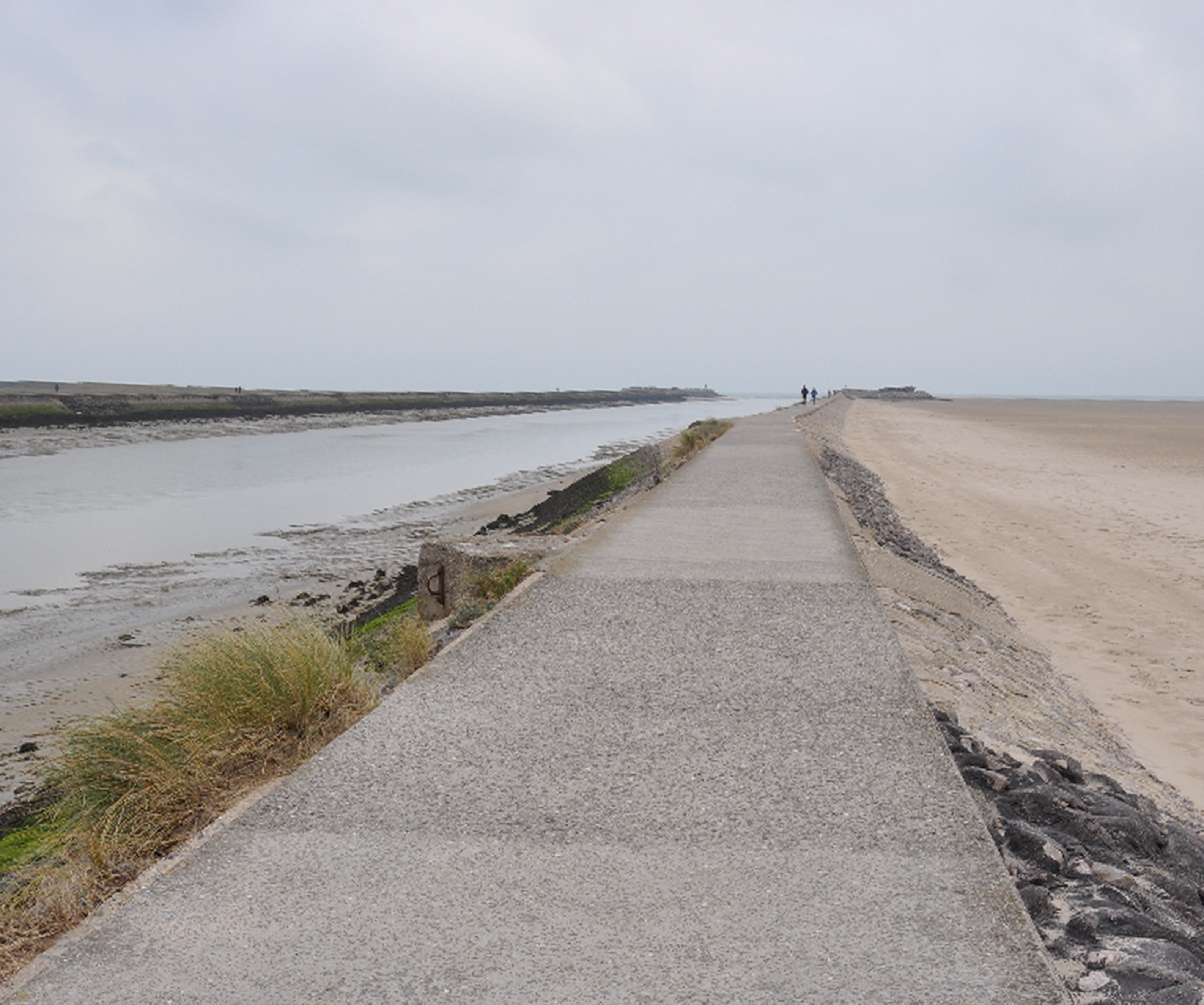
Vision: Gravelines, France
The Gravelines vision is to take advantage of the natural supply of sand deposited by the sea currents on the beach and the foreshore, which the wind then blows further towards the coastline. Developing a simple system of wooden fences that stop sand from being blown will create a natural sea wall that is high enough to protect from rising sea levels. The sand accumulates around the fences, after which vegetation such as marram grass will take over. Marram grass fixes the sand and increases the stability of the dune area. Elevated, wooden paths are constructed to enable visitors to walk through the dune in a controlled manner. The paths were designed to face east to take into account the sand currents caused by the wind.
Vision: Newlyn, UK
To protect the town from the increasing risk of wave overtopping, from the Coombe River it was envisioned that the breakwater needsedto be reinforced, raised and extended. The current breakwater is made up of traditional granite rock. This smooth granite surface is difficult for marine life to settle on and does not attract a wide variety of species. In this pilot the Environment Agency are exploring low-carbon concrete material that is specifically designed to attract marine life and where the CO2 emissions from production and transport are as low as possible. Rethinking the way to design and build traditional rock and concrete defences in some places.
Find out more: Video (English) - Newlyn NBS eco-reef pilot (Appin Williamson)
Dunes to the West of Oostende - 1706.
Eco-blocks from Newlyn.
Find out more:
Video (English): Applying hybrid NBS (William Coulet)
Video (English): Applying NBS – Saltmarsh (William Coulet)
Video (English): Applying NBS – Dunes (Dries Bonte)
With a vision now in place quantifiable models are developed and tested. These can then be adjusted after assessing technical considerations.
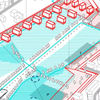
Strategies: Vlissingen, the Netherlands
To test the waves overtopping the dike scenario and then being channelled to the Spuikom, a hydrodynamic model was used to simulate a 1000 year storm. The model looked at an overtopping discharge flow values produced by a storm with a return period (RP) of 10,000 and two climate change (CC) scenarios, extreme W+ and moderate G, at the year 2100 were tested. This scenario considers a sea level rise of 1m by 2100 and a RP 1:10.000; these values are taken to perform the comparison between the current situation (baseline strategy) and the Spuikom Model for coping with sea level rise. According to the hydrodynamic model, 275,000 m3 of excess water is estimated to flood the Spuikom at the peak of the storm. On the other hand, the recovery of additional storage capacity makes it possible to achieve a retention capacity for the Spuikom of 186,000 cubic meters (140,000 m3 on S2 and 46,000 m3 on the S1). The remainder (89,000 m3) must be managed by the Watersgang. With an outflow of 5 m3/s generated by a pump installed at the opposite end of the channel, the Watersgang can drain up to 18,000 m3 over the storm duration. The remaining 71,000 m3 can be stored in the channel itself, resulting in an increase in the average water level of 0.41 m.
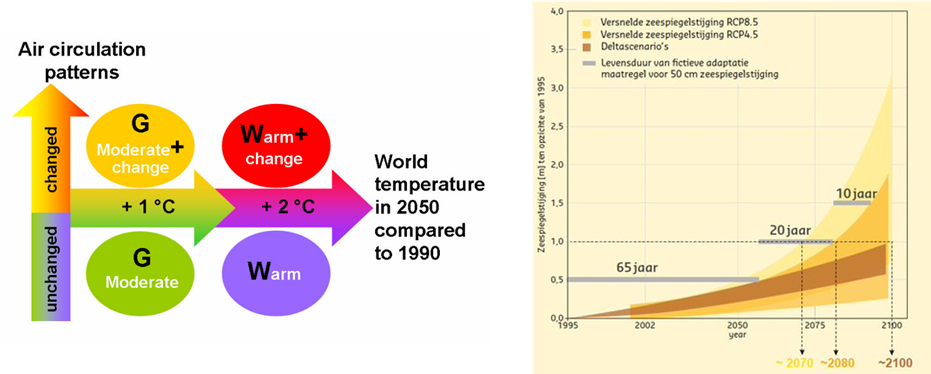
Climate change scenarios. Click to enlarge (opens in new tab).
Strategies: Southend-On-Sea, UK
The pilot at Southend on Sea was to consider a range of different nature based solutions , each in discreet areas located at points along it’s marine frontage from Two Tree Island in the west to east Beach in the east. While the most suitable schemes were being identified, a holistic approach consisting of four sub-strategies was taken to assesses the length of the Southend on Sea waterfront. Firstly, the topo-strategy, which focuses on place-specific water management strategies in relation to the inherited urban structure (density and typology) and soil type (e.g. rainwater infiltration in the high ground’s permeable soils, seawater retention in the low-lying impervious soils; secondly, the eco-strategy, that relies on the existing blue and green networks to reinforce their role of landscape connections and improvement of water and soil quality; thirdly, the accessibility-strategy that mainly focuses on giving priority to the active mobility (pedestrian and cycle) to provide widespread access to the seafront and finally the longue-durée strategy which places greater emphasis in research, protection and preservation of the local cultural heritage.
Find out more:
Video (Dutch): Biodiversity in the dunes / Biodiversiteit in de duinen (Dries Bonte and Sam Provoost)
Video (Dutch): The future of agriculture in the polders / De toekomst van de landbouw in de polders (Jeroen De Waeghemaeker)
Presentation (French and Dutch): Een educatieve benadering van de duinen, hoe gaat men te werk in Frankrijk - Bart Bollengier
Presentation (Dutch): T.OP Kustzone: aan de slag in de duinen vanuit een samenwerkingsperspectief - Stijn Vandereheiden
Presentation (Dutch): Duinen, onze natuurlijke kustbescherming (Peter Van Besien)
Presentation (Dutch): Onze duinen: hoe deze belangrijke bron van drinkwater ons beschermt tegen verzilting (Thomas Hermans)
A final design for the solution is created based on the previous stages and public and stakeholder feedback. The design integrates both the needs of humans and of nature. The social, environmental, and economical values should be synergised into the spatial design to enhance spatial quality and legibility.
Design and NBS Benefits: Vlissingen, the Netherlands
The NBS measure implemented in Vlissingen adapted a street so it could become a river when the seawall was overtopped and additional vegetation was planted to filter and store water. The street was redesigned toimprove the quality of the public space, while channelling excess water down the street, through and around the planted infiltration beds to a retention area (Spuikom).
This measure has multiple benefits in the coastal city of Vlissingen: flood safety, more spatial quality plus ecological, recreational and social values while respecting the historical and cultural significance of the city.
The project was successful because the design has been implemented and supported by the public, despite initial reservations. Citizens were ultimately positive about the idea of accepting water on their street and ‘turning it into a river’ to reduce the risk of flooding once they understood the concept. The municipality acted as a ‘boundary spanner’ by taking on the initiative of urban coastal flood risk within their role of spatial planning. The project is considered externally successful because mainstreaming of NBS started during SARCC. As a result of the project, the involved citizens changed their mindset about NBS for coastal protection.
.jpg)
Vision for the spacial quality of the area. Click to enlarge (opens in new tab).
Design and NBS Benefits: Middelkerke, Belgium
The municipality of Middelkerke initiated the project to plant vegetation and build a green dune in front of the existing dike: dune before dike. Vegetated dunes have multiple benefits for Middelkerke city: more flood safety, less coastal erosion, and more spatial, ecological, economical and recreation values. Citizens find the beach more attractive, greener and nicer for recreation. Dunes restore contact between nature and the sea. They are cheaper to construct and more flexible to manage than hard sea-wall structures which require large investments and have only a limited shelf life because of unpredictable sea level rises. With the new grass dike, Middelkerke is protected against a 1000-year storm until 2050. But if the sea level rises more, thanks to its natural structure, the dune can simply be raised giving a flexible sea wall.
The amenity value has also increased where the grass dike widens and upgrades the public space by over 100,000 m2. The area now enjoys sun throughout the day as it is not impacted by the shadows that are cast over the promenade by the flats in the morning and the afternoon.
The green dune covers a total area of 11,5 hectares from what 10,5 hectares is being planted with marram grass. In terms of carbon sequestration, a total yearly carbon capture of around 4,4 gr CO2 ha-1 of the entire project is expected. The Green Infrastructure validation tool expects an increase in land and property value of 9,5 million euros. As the project of Middelkerke might be capable of encouraging at least 3 hours of exercise per week, it’s possible to apply the reduced mortality tool. The calculated reduced mortality benefit is 167,000 euro/year, resulting in a net present value (NPV, the value in present terms, accounting for all the net benefits the project will bring over their lifetime) of 1,12 million euros over 10 years. The benefit estimation tool expects amenities to increase by 17 million euros, based on the number of visitors to the project, the average amount of spending per tourist and the real estate pricing and amount of flats in the vicinity of the projects. The savings gained from a reduction in sand cleaning due to the planted marram grass will be 384,618 euros.
Middelkerke waterfront.
Design and NBS Benefits: Oostende, Belgium
At Oostend the beach was raised creating a ‘dune-before-dike’ over a length of 700m. The principle is similar as that seen a short distance away at Middelkerke, where a green dune is planted with a covering of marram grass, meaning the dune will retain the sand, preventing it from blowing inland.
The municipality will save 11,273 € per year in cleaning costs of sand because the marram grass covered dune will act as a sink and store. Surveys in the city of Oostende revealed that tourists are willing to pay a higher price for green infrastructure when compared to residents. Moreover, 58% of the people surveyed indicated that green infrastructure at the coast is more attractive and that they would come specifically for this. This has a result on the land & property values in the vicinity of the project. GI-Val expects an increase in land and property values of 2.3 million euros.
Marram grass and additional greenery will give more possibilities and habitats for fauna and flora, thus increasing biodiversity, which is valued at an additional 2,500 euros yearly. The increase in attractiveness of the beach enhances the amenity value which is expected to be increased by 6,88 million euros.
Oostende pilot area and waterfront.
Design and NBS Benefits: Blankenberge, Belgium
At Blankenberge, the existing coastal dune has been significantly widened creating a “dune-before-dike”, providing additional protection against sea level rise.
The town of Blankenberge has invested heavily in so-called depaving projects in recent years to not only bring more nature into the city, but mainly to allow rainwater to seep into the soil. On the coast, Blankenberge suffers from a groundwater table that is far too low. This can lead to problems for the drinking water supply and for agriculture, especially in the dry but busy summer months. By enlarging the dune foot over a distance of 700m, the wider dunes provide a greater buffer against the salinisation of the polders behind, while also giving a strong boost has been given to nature and biodiversity. The fresh groundwater in the dunes creates an additional barrier against salt water ingress from the sea.
The Blankenberge project shows the highest increase in land & property values, similar to the other 2 Belgium projects, with a total increase expected of 5.96 million euros. As the Blankenberge project is the only project where tree planting is involved, it has the highest value concerning carbon sequestration. In total 351 tonnes of carbon will be sequestrated in the following 10 years, resulting in a monetary value of 24,800 euros. The biodiversity and ecology factor of the newly planted trees is expected to have a value of 1,668 euros.
Blankenberge pilot area.
Design and NBS Benefits: Gravelines, France
The project in Gravelines involved the construction of wooden piles placed strategically in front of the shrinking dune system with the aim of revegetating the existing dunes via wooden faces and replantation. Elevated wooden paths allow visitors to walk through the dunes in a controlled manner which also protects the vegetation.
These combined NBS measures have brought multiple benefits. They offer better protection against flooding, less coastal erosion and more ecological value. A higher, wider dune looks better and is good for biodiversity, plants grow more easily in a thicker dune and animals come back to the beach and roam the pilot site. The project is also popular with residents and tourists. The pilot shows that major challenges can be tackled with simple, low-cost solutions and at the same time strengthen nature and biodiversity. Unlike hard concrete structures, this nature-based solution is cost-effective.
Gravelines pilot area.
Design and NBS Benefits: Newlyn, UK
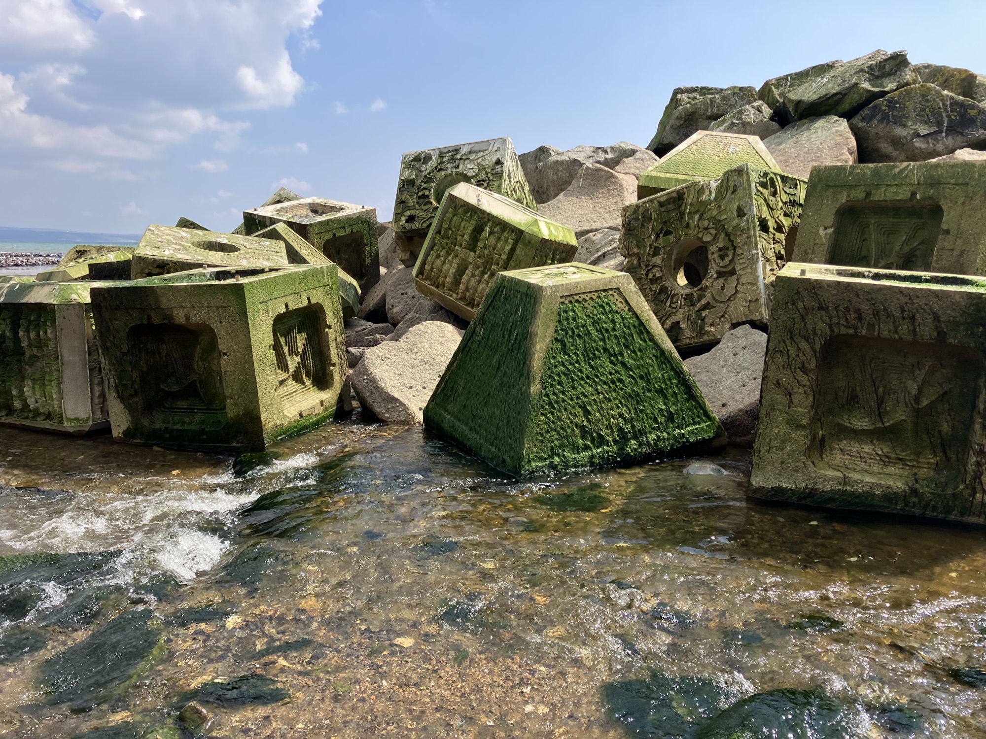
The Newlyn pilot is an investigation into the use of innovative technology, being eco-blocks in intertidal zones for the first time in the UK. The project has provided an opportunity to monitor and gather evidence of their effectiveness for future coastal management schemes that plan to ‘green’ traditional forms of hard coastal defence infrastructure. The first results from monitoring show that the eco-blocks are increasing the effectiveness of the breakwater as they are quickly colonised with marine vegetation. As a result they offer multiple environmental benefits: ecological (increase marine wildlife), spatial, recreational, social, historical and cultural.
The Newlyn pilot was a research and development initiative to test proof of concept. As the current coastal management policies encourage the implementation of NBS but do not provide a clear legal framework on how to deliver them, this innovative solution is now being studied to assess the suitability of eco-blocks as a low-carbon and nature-inclusive alternative to traditional engineered defences. If they continue to prove successful, they could be deployed elsewhere on the UK coast and provide evidence that will support the mainstreaming of NBS in the UK.
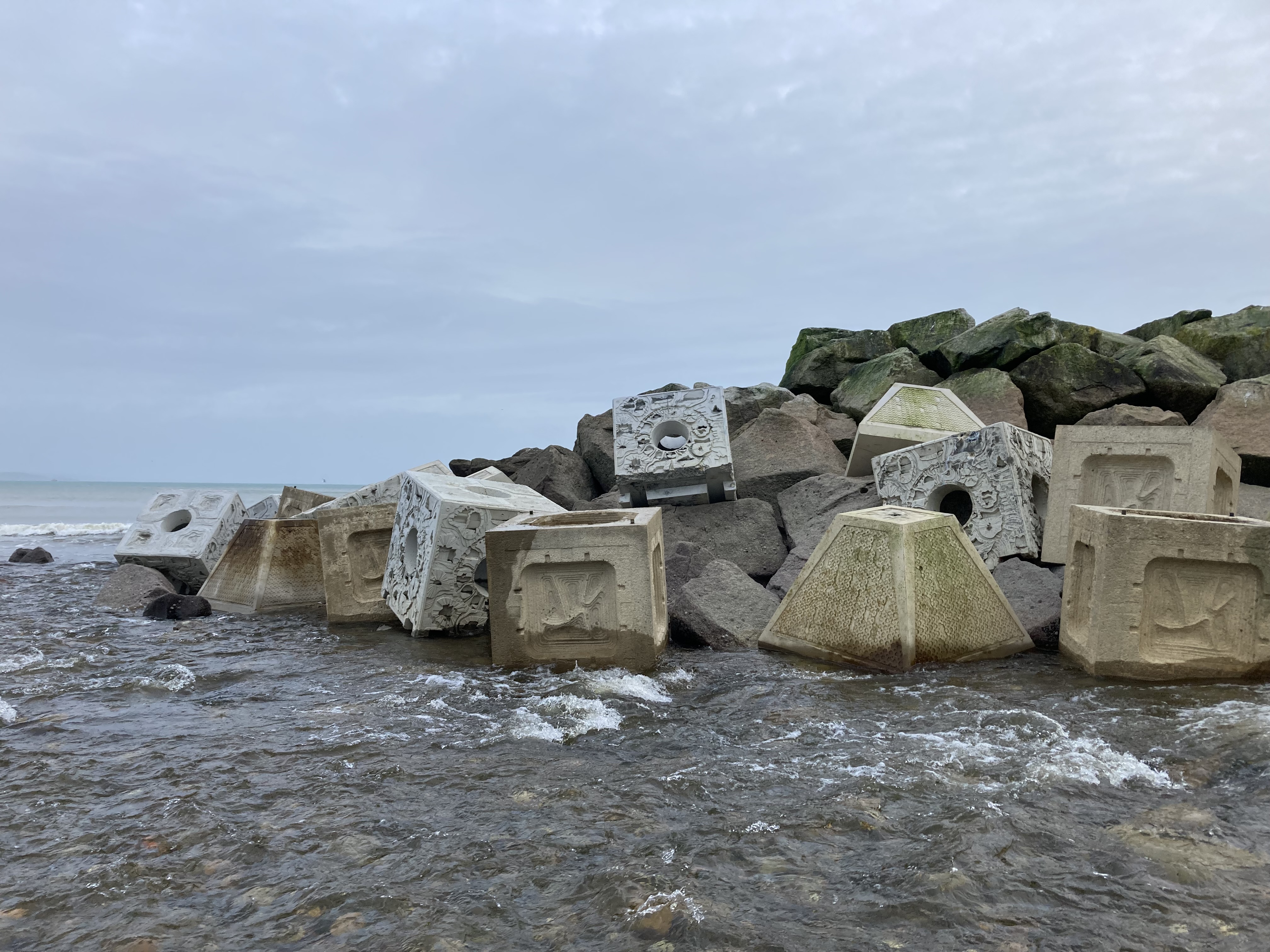
Roundhead eco blocks in the Newlyn pilot area.
Example: Southend-On-Sea, UK
Nature based solutions that were trialled in Southend on Sea included first, vertipools, being small pools fixed to hard coastal defence structures that absorb wave energy and provide an ideal substrate for marine life; secondly, a restoration of the dune system with endemic plant species along East Beach; thirdly, the creation of a green wall to protect the Two Tree Island coast from erosion and finally, the taking of a sympathetic approach to Southchurch and Thorpe Bay beaches by managing the introduction of vegetation and by reducing aggressive cleaning activities.
Monitoring is ongoing as these pilot sites had only recently been completed before the conclusion of the SARCC project, however, along Southchurch and Thorpe Bay beaches the resultsare already visible where different types of plants have started to grow spontaneously. A botanical study of the beach showed that twenty-two coastal species of halophytes or salt-tolerant plants such as sea kale, sea holly, sea lavender, Sand-hill Screw-moss and Sea Mayweed, are now thriving. In addition, the roots of the plants have stabilized the beach, reduced the impact of longshore drift and slowed down erosion. Historically, when there was a storm, sand cliffs would be cut into the beach. Now the beach remains flat, hardly any material disappears and less sand is getting blown over the seawall onto the footpath and cycle path.

Roundhead eco blocks in the Newlyn pilot area.
Find out more:
Video (English): Workshop Modelling and measuring benefits of NBS – session one
Video (English): Workshop Modelling and measuring benefits of NBS – session two
Video (Dutch): A cost-benefit comparison based on ecosystem services (Katrien Van der Biest)
Reset View
Pilot Areas
Themes
Tools
Help
Mean sea level rise (SLR) could increase by 1.5m-2.5m by 2100, which would see damage caused
by coastal flooding in Europe increase from €1.25bn per annum currently to €961bn in just
over 80 years (European Commission, 2018). Urban areas situated along the 2 Seas coastline are
particularly vulnerable to extreme SLR (a combination of SLR, tide and storm surges). Coastal flood
plans and policies focus predominantly on deploying traditional grey infrastructure/heavy
engineering and ignore the use of nature-based solutions (NBS), despite the overwhelming
evidence of their potential to reduce flood risk and provide multiple benefits.
NBS are often not considered by policy-makers in detail due to the perceived risks around costs,
potential for success, requirements for immediate protection / improvement and uncertainties
regarding future change. A clear knowledge gap exists across coastal local authorities to deploy NBS
as a means to reduce future coastal flood risk and economic damage.


The data used in this visualisation tool has been both supplied by project partners and collected
from a range of sources, including local heritage records, Geopunt.de, Klimaatportaal, CORINE, and
the
Future Coast project.
Every effort has been made to track down the copyright owners of all data included within this tool.
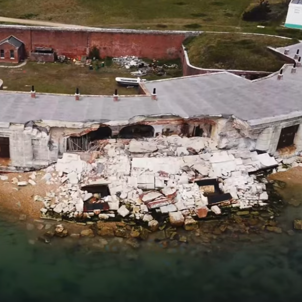
The Newlyn Eco-Block Research pilot is located adjacent to Newlyn Harbour, Mount’s Bay in Cornwall, UK. The pilot project involves deploying low-carbon eco-blocks on and around an existing breakwater, to research a more nature-based solution to coastal defence which could deliver multiple benefits. It is anticipated that this location will enable trials of the new blocks in a high wave energy intertidal environment. The findings from the pilot project will inform applications for the blocks in future breakwater construction projects around the coast to assist in managing climate change-induced risks from coastal erosion and flooding. A number of different suppliers of eco-block products have been used in the pilot, each of which aim to provide a bespoke substrate for marine organisms to colonise and develop living structures.
Historically, this area has relied primarily on land-based static and inflexible protection. This is in response to the flood and erosion risks which exist throughout Mount’s Bay, as well as across the wider coastline of Cornwall, which are further intensified by the effects of climate change and sea level rise. As such, the local shoreline is heavily developed and structures modify the natural coastal system rather than work with it. The Newlyn Eco-Block Research pilot is trialling engineering products that could be used in the future to reduce wave energy at the shoreline and promote growth of natural beaches behind, creating a wider risk management zone. The eco-blocks have been designed with surface texturing inspired by natural nearshore rocky habitat and features shaped to encourage colonisation by algae and other marine life, to improve local marine biodiversity. The over-arching aim is to demonstrate an approach which is more adaptive and environmentally beneficial in the longer-term.
The exposed coastal frontage of Newlyn is at risk of coastal flooding particularly when there is
a
combination of high spring tides, low barometric pressure and strong gale force south westerly to
south easterly winds. The high water levels can combine with large swell events resulting in
coastal
inflow to the Newlyn Coombe River. These raised water levels and wave propagation can result in
violent surge and overtopping of the river banks and sea defences. These conditions present a
flood
risk to properties, and a danger to pedestrians and vehicles.
At present, there is a small rock breakwater attached to the Newlyn Harbour wall in the mouth of
the Coombe which is built to provide shelter from the waves. However, the dimensions of the
current
breakwater are not enough to provide effective protection from waves during these conditions. The
Environment Agency has worked with consultants to develop models to better understand the current
flood risk here. In 2013, the Environment Agency completed a model to better understand the
coastal
flood risk in Mounts Bay. The modelling outputs suggest a 2004 event could cause there to be
significant coastal flooding at Jack Lane Road and surrounding residential and commercial
properties. The flood risk could also block the main entrance point to Newlyn Harbour and the fish
market which plays a major economical role in Cornwall’s fishing industry.
In 2019, the Environment Agency ran a numerical modelling study to investigate the cause of severe
wave overtopping in the project area. The study calculated that the Valentine’s Day storm on the
14th February 2014 caused there to be maximum time-averaged overtopping rates during the half hour
simulation of approximately 80 litres per metre per second at the slipway situated directly south
of
Jack Lane Bridge. This is a significant volume of water and mirrors what was observed during the
Valentine’s Day Storm in 2014. Observed historical storms are known to have damaged property
windows
due to breaking waves and airborne debris and 10 residential and 2 commercial properties are
confirmed to have flooded.
Coastal flooding in Newlyn has occurred frequently with major events including the 14th February 2014 Valentine’s Day storm and the October 2004 event. Both of these events resulted in the issuing of severe flood warnings. The 2004 storm event is suggested to have a slightly larger flood extent compared to the Valentine’s Day storm, most likely caused by the high water levels recorded in 2004. Video footage of the October 2004 event was used to suggest that the breakwater at the mouth of the river was overwhelmed during this event, which subsequently caused flooding along the frontage. Both events caused property damage, with overtopping waves and airborne debris colliding with infrastructure and development. In 2004, 10 residential and 2 commercial properties were flooded. In addition to the residential properties around Tolcarne Terrace and Lower Art Gallery Terrace which are affected, commercial properties including the Newlyn Harbour Offices, The Tolcarne Inn, Tolcarne Garage, The Fisherman’s Mission, Warrens Bakery, Co-op supermarket, Newlyn Surgery, Newlyn Pharmacy and Harbour Hairdressers are examples of the commercial property at risk from tidal flooding. All of these are located within the impacted area. Similar impacts were observed during the 2014 event. Some of these events have been used as baselines for the Environment Agency hydraulic and numerical models and have supported building the case for this project.
The project area has already experienced significant coastal flooding with the most recent major events caused by coastal storms including the 2014 Valentine’s Day floods and the October 2004 event. Climate change projections show water levels will rise and storm events will become more severe and frequent in the future. Modelling commissioned by the Environment Agency in 2013 suggests an event similar to the 2004 storm event will increase the extent of the flood risk area at the mouth of the River Coombe in the next 100 years. This will subsequently put more residential and commercial properties and infrastructure at risk of coastal flooding. There is also an erosion risk which is an increasing problem for Newlyn into the future. The Shoreline Management Plan (SMP) identifies potential landward erosion of up to 85m along the adjacent Foster-Bolitho Gardens frontage from 2105 and historically, significant episodic erosion events have occurred along Newlyn’s frontage in response to storms. The exposed location of the project area to south-easterly to south westerly waves means there is also a significant risk of infrastructure and property damage through wave overtopping caused by coastal flood events. Theoretically, if the current Newlyn breakwater was to fail, this would significantly increase the coastal flood risk to the commercial and residential properties and the Strand Road which runs along the frontage of Newlyn Harbour. It has also been identified by the SMP that failure to maintain defences would ultimately result in structural failure and some loss of Newlyn’s harbour margins.
The intention of the pilot is to complement the natural nearshore rocky outcrops which exist within the local area by using products that have been designed with features such as rockpools, crevices and rough surface textures. The innovative, low-carbon materials and block designs will also test emerging ideas on ‘greening-up’ more traditional types of hard coastal infrastructure. The Newlyn Eco-Block Research pilot will deliver an opportunity to gain experience of how Nature Based Solutions can address problems experienced in high wave energy environments. By deploying and monitoring a variety of eco-blocks, it is intended to establish which properties such as substrate material, habitat features and block position give the best chance of marine organism colonisation in this type of environment, whilst also being suitable for the construction of reefs and breakwaters. It is intended that the results will inform the design of future coastal defences which will become living structures, harnessing the adaptive capacity of natural coastal processes.
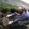
Mini eco-block trial
In early November 2020, the Environment Agency, Exo Environmental and contractors met at the pilot site in Newlyn to deploy 12 trial eco-blocks and complete baseline monitoring. The Newlyn Eco-Block Research project is one of several pilot projects being delivered by Sustainable And Resilient Coastal Cities (SARCC) which is trialling nature-based solutions to address climate change and sea level rise. The prototype blocks, each weighing around 75kg, are manufactured from a granitic particulate by-product, sourced from a local quarry stockpile. The trial was carried out to help us identify optimal surface textures for larger eco-blocks to be used in the full-scale pilot. Ecological monitoring was then carried out by the Environment Agency over the next 24 months to determine colonisation rates and species type.
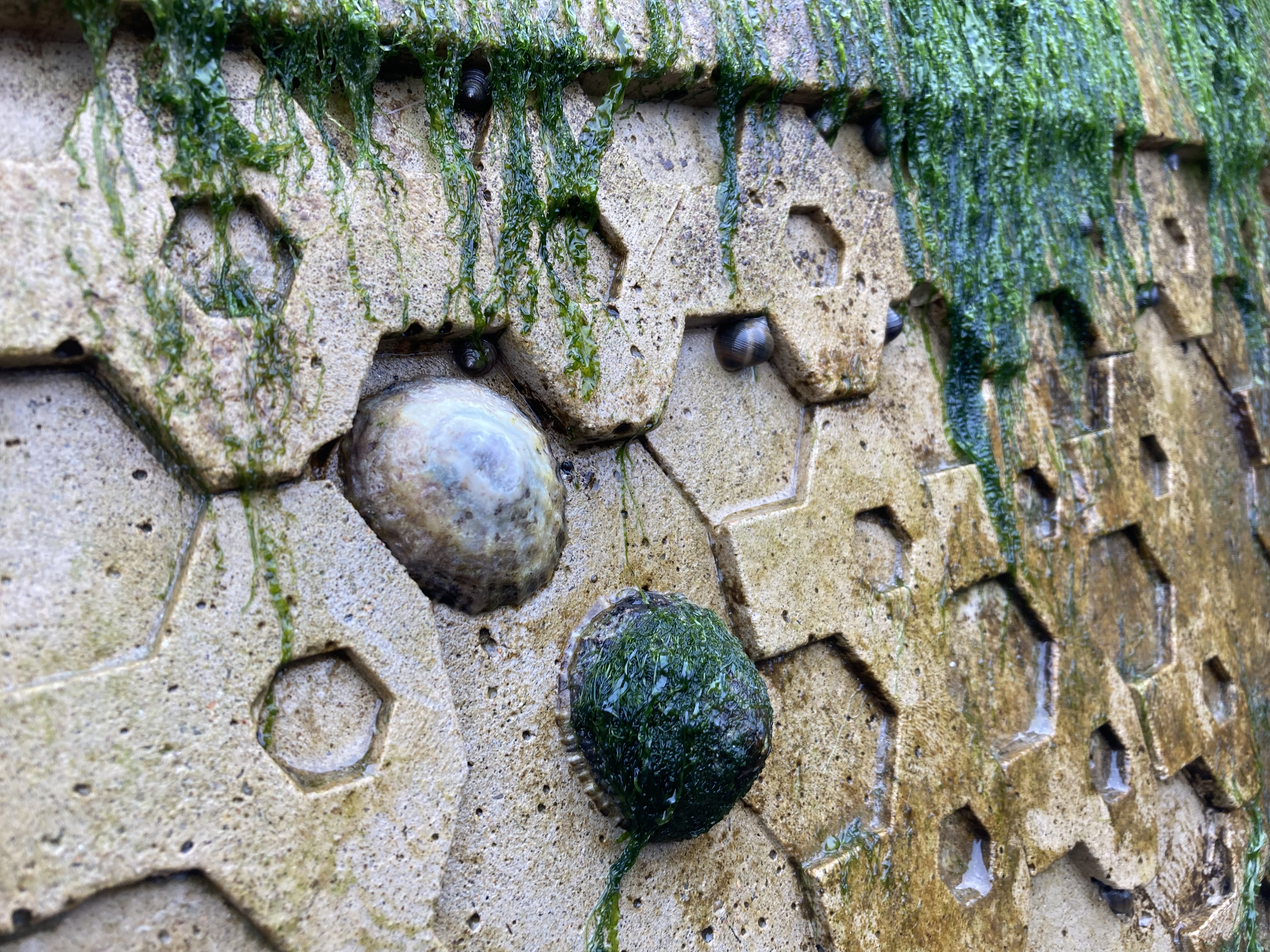
By July 2022 the trial eco-blocks had developed a good coverage of algae including gut weed and spiral wrack. Species of periwinkle and limpet were also recorded on the blocks, using the textured surfaces for shelter, with sea slaters, barnacles, toothed topshells, mussels and anemone also being recorded in autumn 2022.
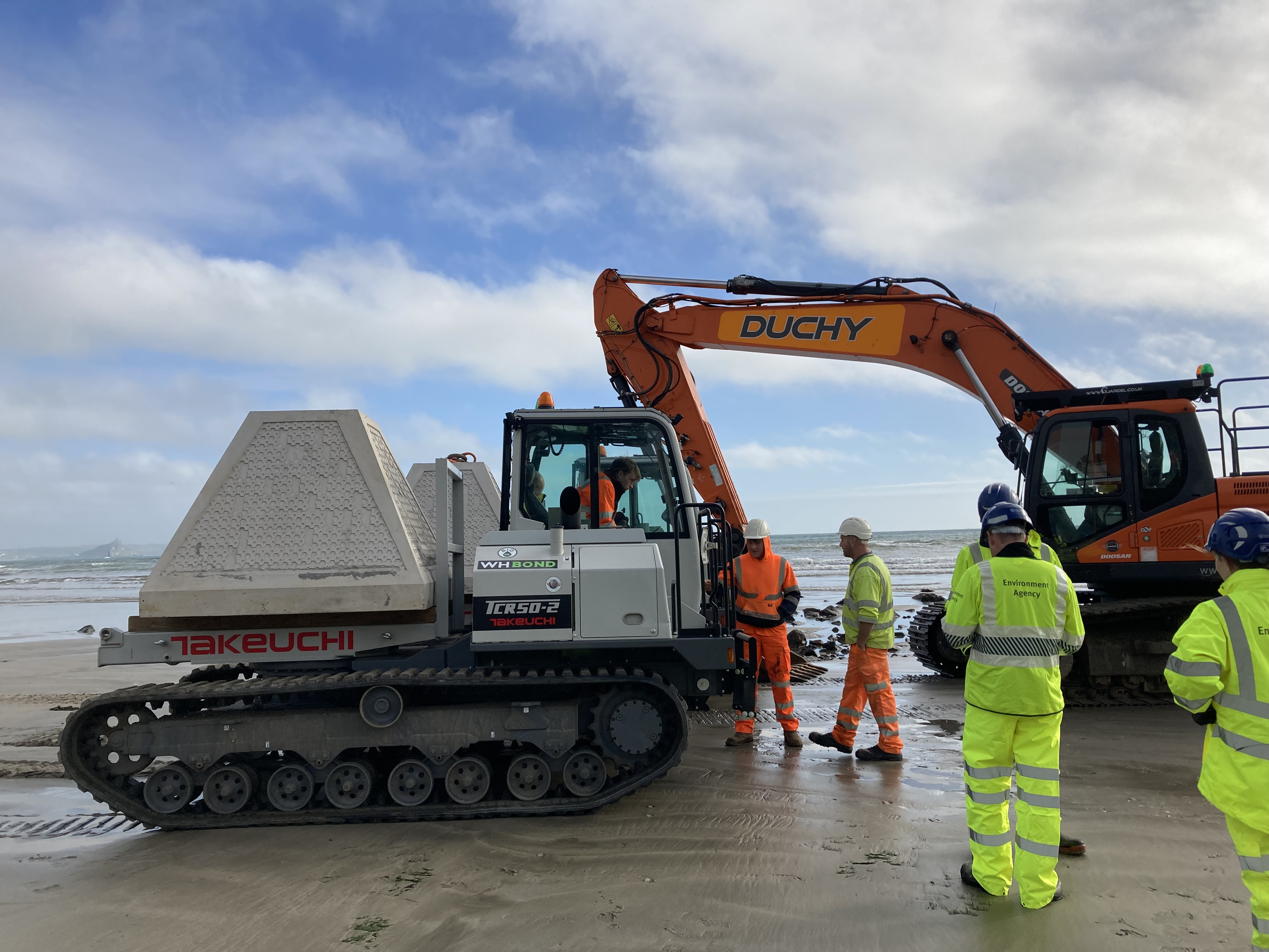
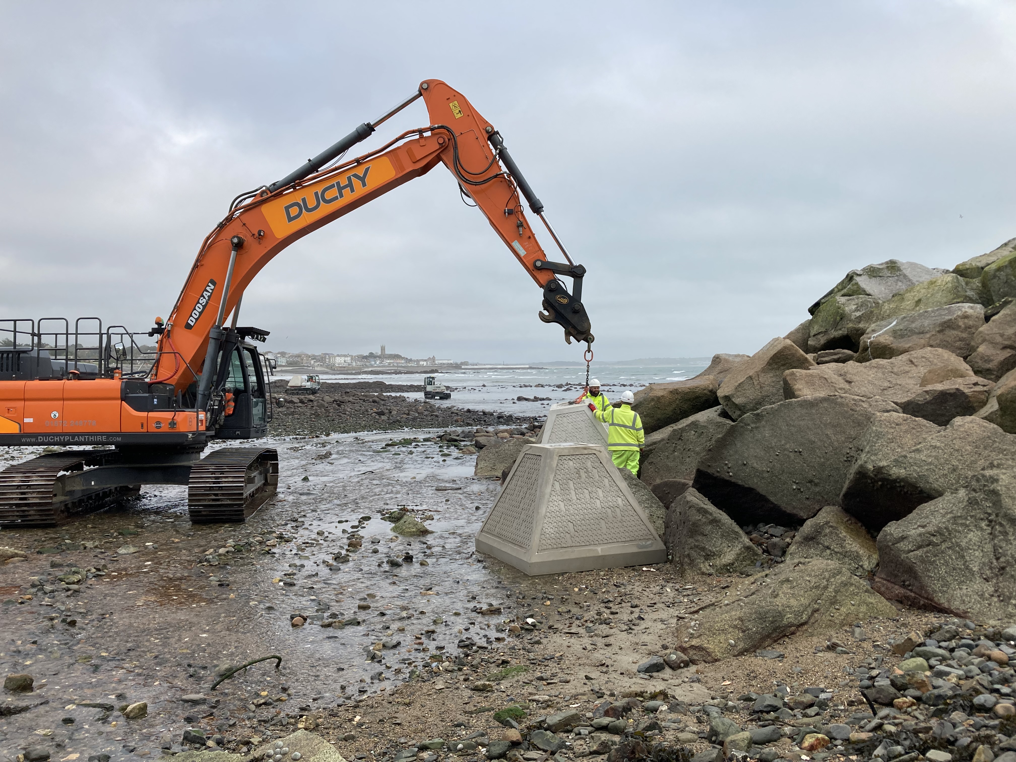
The project team continued to work on plans for the full-scale pilot. The necessary planning permission and marine licence were obtained from the Local Planning Authority and Marine Management Organisation respectively. The Environment Agency and partners at Atkins and Kier worked to select a range of eco-block products from different suppliers for use in the full-scale pilot. These eco-blocks are each around 4.8 tonnes and are made using recycled and low carbon materials.
Pilot Construction
During winter 2022/23 a total of 88 new eco-blocks were installed on and around the existing granite breakwater at Newlyn. The eco-blocks are being trialled as a form of coastal protection which also acts as habitat for marine life and is made using low carbon and recycled materials. These characteristics set eco-blocks apart from materials such as traditional concrete and quarried granite, which are more commonly used to build coastal structures but have a larger carbon footprint and offer fewer benefits for wildlife. The pilot includes 4 different suppliers: ARC Marine, ECOncrete, Exo Engineering and JP Concrete. Each eco-block design featuring a variety` of habitat niches, pools, surface textures and altered surface pH to encourage rapid colonisation by marine life. After just a few weeks, the project team were pleased to see that the eco-blocks were already being colonised by marine life including algae, snails and limpets.
The Environment Agency will continue to monitor the performance of the eco-blocks and will share the results with the public and other coastal authorities. It is hoped that the findings from this work will help inform future flood and coastal risk management projects where eco-blocks could be a potential solution.
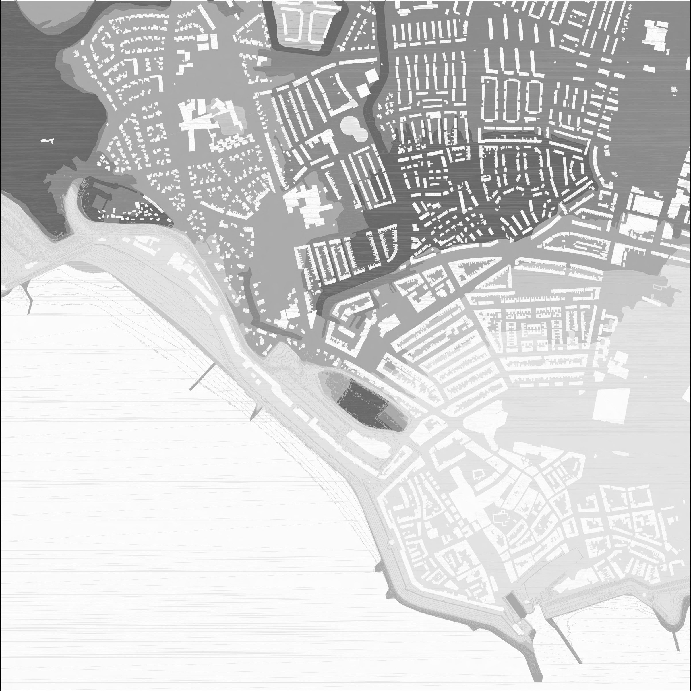
Southend on Sea is located on the mouth of the Thames River and served by a capillary transport
network which includes an effective road system and multiple train stations. Its waterfront has
been, historically, an important leisure and recreational area. It has over 180,000 inhabitants and
is the most densely populated area outside London.
The city has spread out from important centres of activity near the waterfront. The urban areas are
dominated by single-family houses with gardens, whereas public and commercial services are
concentrated along several high streets and recreational grounds (e.g. sport fields). Property
development pressure is strong, particularly along the seafront due to its high economic value.
From a geomorphological perspective, the municipality is divided into two parts: the town centre and
western part are located on high ground, while much of the sea front and the eastern part is on
lowland at flood risk from the sea. However, due to soil sealing beneath urban developments, the
risk of pluvial flooding is also common along upland waterways.
Southend on Sea is an area that has a long and significant history of human habitation. Evidence of
the earliest activity is represented by hand tools left by people throughout the stone Age,
following which there is Bronze Age, Iron Age and Roman settlement.
From the Middle Ages onwards, as threats off invasion grew, the area became a significant line of
defence. It saw several battles and hosted a warning beacon from the 13th century and in the middle
of the nineteenth century, a permanent garrison was established. As a site of longstanding
importance it has a rich historical record that can be assessed to help understand past change.
The coastal evolution and the human impact on its development is an important to be taken into
account as the local authority looks to introduce new defensive nature based solutions. The area is
under threat from sea level rise and increasing storminess due to climate change. This is subjecting
the coast to increased erosion. Understanding the long term processes can inform us about ongoing
trends. It can help us interpret past, natural responses to coastal change and identify the impact
of human developments, allowing us to compare and consider the most effective forms of defence.
The coastline between Leigh on Sea and East Beach has varying degrees of threat. As part of the
SARCC project, Southend on Sea City Council, will be setting up seven environmentally sustainable
pilot schemes that use nature based solutions to mitigate the impact of the sea.
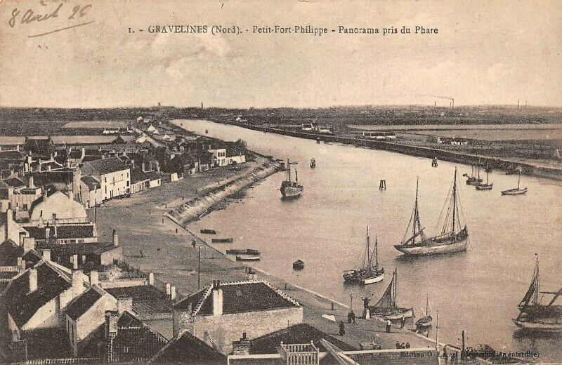
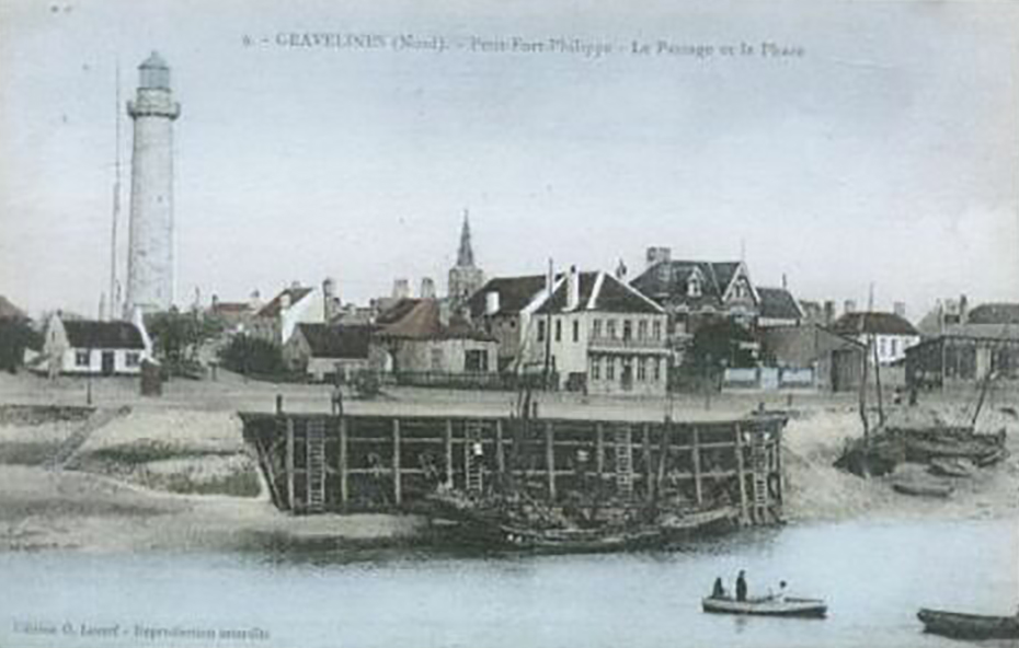
Gravelines, a beautiful coastal city located between Dunkirk and Calais, has a rich history, not
only in terms of architecture, but also in management of marine submersion and floodings thanks to
the “wateringues” system consisting of hundreds of kilometres of canals.
The functioning of our pilot is simple : strengthening the existing dune. In order to create a
high enough natural wall against the dangerous combination of waves and high tide, we developed a
simple system that literally traps the sand, thanks to wooden fences. While sand accumulates
around these fences, small vegetation tends to grow in the sand and in turn reinforces the
thickness and stability of the dune.
Gravelines is situated under sea level, just like large parts of Belgium and the Netherlands.
Therefore, we are highly vulnerable to maritime submersion.
Luckily, and unlike many cities on the Cote d’Opale region that suffer from constant loss of sand
on their beach, sand tends to accumulate on our coastline, a phenomenon called accretion.
We also dug elevated pathways to allow small bats and people to go through the sand dune while
protecting lands and people from water flooding : once again we take advantage from the wind and
the sand and trap it thanks to wooden fences and wooden flooring to stabilise the pathway. The
pathway faces eastward as you can see to take into the equation sand flows through wind . We had
to strike a balance between the different uses of the beach.
There are many benefits to the pilot, beyond a better protection against maritime submersion: a
higher sand dune definitely looks better and it is beneficial to biodiversity: plants more easily
grow in thicker dune and animals are coming back to the beach, roaming around the pilot site.
We benefit from a natural advantage of Gravelines: sand accumulation. The simple deployment of
fences to trap the sand was enough to use nature as a tool to better protect our
community.
This project demonstrates if need be, that we can address major challenges with simple solutions
while preserving nature and biodiversity ! Thanks to SARCC we are now more resilient in a
sustainable way : unlike hard concrete structures, this nature-based solution is cost effective.
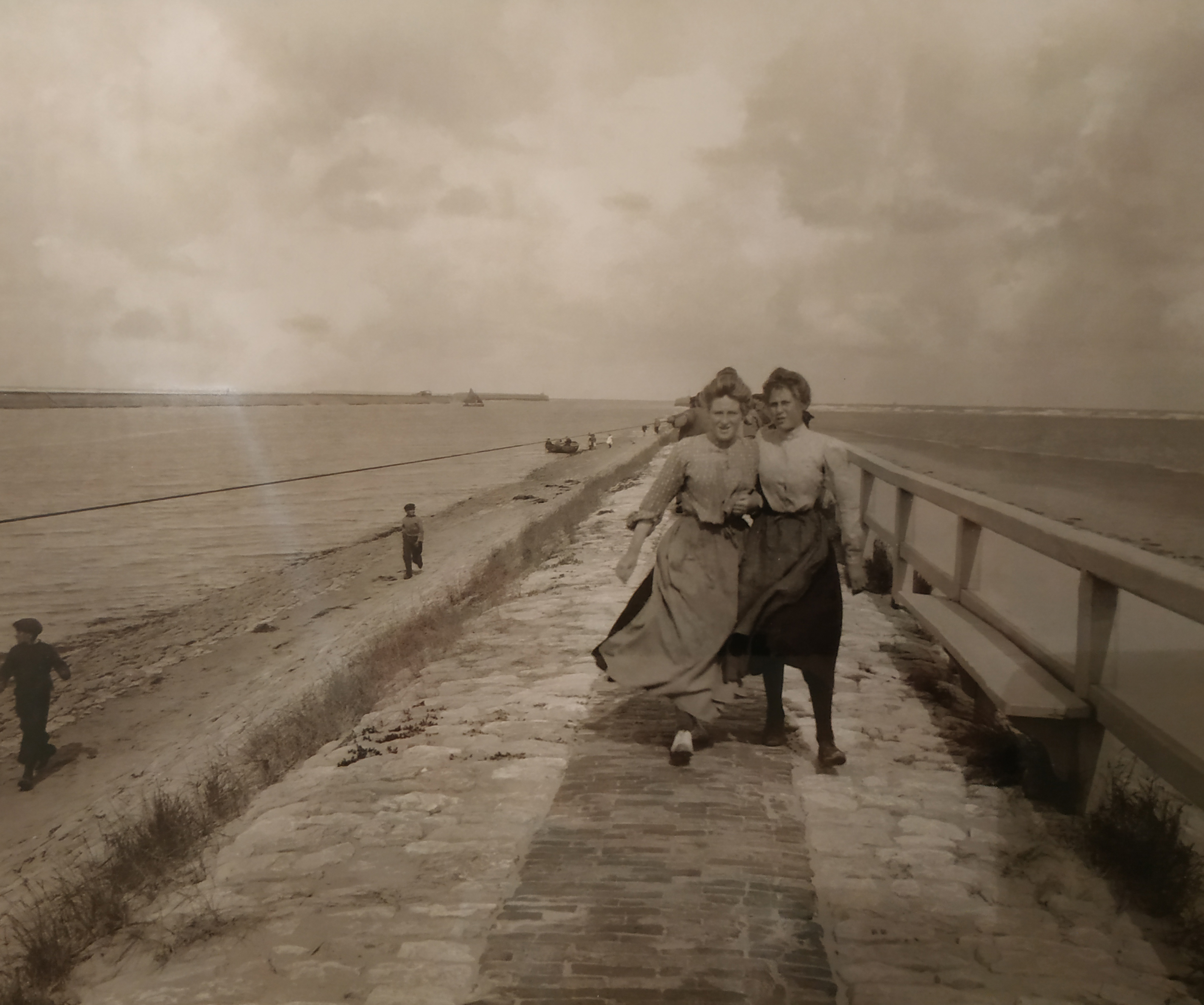
Click the thumbnails below to compare historical images with modern photographs.


This pilot is set on the coastline of Middelkerke in Belgium. It’s the intention of the municipality of Middelkerke to strengthen coastal defences against the 1,000-year storm and sea level rise. The objective of the pilot is to replace the existing measures (beach nourishment) by permanent investments. Before this, we could choose to strengthen the existing dike. This was however never done. In the tourist trade zones we will have to build a strong structure (wave damping expansion). The work is planned with a nature-based solution. Between the surf club and the Noordzeelaan, a soft sea wall in the form of a grass embankment (controlled dune) will be applied. With a controlled dune, this will mean that we can check it’s height in terms of sightlines and use.
The advantage of this nature-based solution is that its construction is cheaper than the traditional (hard structure) coastal protection. Thanks to the grass dike, more greenery is being realised. The slope of the beach is thereby extended and the zone closest to the current sea dike level is given a sustainable, controllable vegetation with marram grass and other retained species. It can also grow with future higher protection needs (sea level rise) and can provide much added value in terms of experience for tourists, nature and biodiversity.
The pilot is situated at the shore of Ostend in an area where there are no buildings along the beach and seawall. Despite the absence of buildings along this stretch of coast, the area has an urban character due to the presence of the coastal road, the tramline and the seawall with cycling path and walkway.
In the past, Ostend was identified as one of the weak areas where safety standards regarding
coastal flooding weren’t fulfilled. Therefore the Coastal Division of the Flemish Agency for
Maritime Services and Coast has nourished the beaches of Ostend to upgrade the safety level to a
1000 year storm surge event. This was part of the coastal protection scheme that is called
“Masterplan for Coastal Safety”.
In the pilot area of Ostend the excessive sand transport caused by heavy winds lead to a lot of
problems for the use of adjacent infrastructure, such as the walk and cycle path, the tramway and
the
coastal road. Several times a year, sandy hills are formed that make the use of the road and
tramway
too dangerous, forcing them to be closed. Cleaning up the sand requires a lot of effort, is costly
and
takes time. Furthermore, the sand that is being cleaned up can’t be used to nourish the beaches,
shore
face or dunes because there is a risk that it has been polluted by the road or the tramway.
That is why the City of Ostend and the Coastal Division are working together in this pilot by
creating a natural landscape with planted dunes along the seawall. This should lead to an
ecosystem
that keeps the sand on the beach instead of leading it to the tramway and the road. The natural
dynamics of waves and wind will allow a dune landscape enough space to develop.
Instead of building up the grey infrastructure to catch the sand, we will experiment with a
natural
landscape. The idea is that nature will clean up the sand from the road and tramway, whilst also
nourishing the beach.
Nourishments are very effective to reduce the flood risk at sandy coasts, like Flanders. They also
have the advantage of being flexible towards sea level rise: by raising the amount of nourished
sand, the beach can grow with the sea level. However, sandy coasts also have some disadvantages
due
to the very dynamic nature of the North Sea: sand is continuously transported by waves, tidal
currents and the wind. This leads to erosion of some parts of the coast whilst other parts of the
coast are growing due to sand deposition. Traditionally, sand deposition is a good thing for
reducing the flood risk, but it also leads to issues in more urban parts of the coast, as for
example in Ostend. This pilot aims to use a Nature-Based Solution to tackle these issues in a
sustainable, cost effective and eco-friendly way.
The City of Blankenberge is a town and a municipality in the province of West Flanders, Belgium. Blankenberge had a total population of 20.444. The total area of the municipality is 17.41 km², giving a population density of 1,142 inhabitants per km². Blankenberge is one of 10 Flemish coastal town. The Blankenberge coastline consists of a stretch of approximately 4 kilometers of beach and 1 km of dunes. The coastline is interrupted by the marina entrance. The pilot is situated on the eastern edge of Blankenberge behind the dunes, specifically it is part of the A. Ruzettelaan.
The City of Blankenberge is one of ten (more or less) small coastal towns. The approach to coastal resilience is managed and coordinated by the Flemish Government for the whole of the Belgian coastline. In the “Masterplan for Coastal Safety” set out by the Flemish Government, a number of measures to upgrade the safety level against a 1000 year storm surge have been proposed. The nourishing of the beaches in Blankenberge is one of those measures. In the pilot area the dunes will be expanded in an inland direction which will further upgrade the safety level. Apart from the extra coastal defence that will be created, the solution also has environmental benefits such as less traffic related pollution in that part of town.
The Flemish Government approved a Master Plan Coastal Safety in June 2011 comprising calculations and safety assessments for the periods 2000–2050 and 2050–2100. A vision for further development of the Flemish coastal zone is on its way aiming at the integration of safety, natural values, attractiveness, sustainability and economic development including navigation and sustainable energy. This concept is referred to as ‘Vlaamse Baaien’ or ‘Flanders Bays 2100’ and includes conceptual plans for responding to climate change effects beyond 2050 .According to studies executed by higher authorities an average sea level rise for the Belgian coast from 1990 to 2100 of 9 to 88 cm is predicted. A large part of the coastline has been subject to erosion for several decades. Groynes have been built to restrict the erosion by currents and waves. Since 1960 beach nourishments have been carried out regularly to compensate for the erosion at the coastline.
Our nature based solution consists of the breaking up of the surface of a part of the road closest to the dunes at the eastern side of town. This part contains a sidewalk, a bike lane, parking lanes and the actual road over a total width of 11 meters. Apart from a bike lane (width : 4 meters) this part will be “given back to nature”. The already existing dunes will be able to expand over the broken up part of the road, and will create an extra nature based solution,
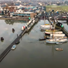
The pilot project in Vlissingen is in an urban area at the mouth of the Westerschelde where the river arm and the North Sea come together. The project provides the design and implementation for a new way of thinking about climate-adaptive public spaces in urban areas by the sea. The objective is to focus on natural and green sustainable measures, which in the long term will protect the urban area against flooding during storms. In addition, research is being conducted into the implementation of nature-based solutions (NBS) in the foreshore and in the primary sea defences. The measures in the pilot are implemented in a street and as part of an area development in “De Spuikom”. The implemented measures must contribute to the natural appearance of the urban area.
In urban coastal areas, the right balance must be sought between coastal defence and urban development. The addition of NBS creates new opportunities for a new way of spatial development. The ambition is to have the aspects reinforce each other. The variety of forms of coastal defence in Vlissingen (beach, concrete barrier, green dike) will teach the various other pilots within the SARCC partnership. The Dutch coastal strip is primarily designed as a sandy coast, which means that valuable cross-border knowledge can be brought in for Vlissingen. If no measures are taken in the area of the pilot, the dike will eventually have to be raised by three meters. This has a very large negative impact on the urban quality of Vlissingen.
The design of the public space protects the inner city of Vlissingen from damage caused by flooding and wave overtopping. Green barriers absorb seawater and carry it off naturally to the urban water system. This limits the chance of damage to property and people. As part of an area development, ‘De Spuikom’ is being made suitable for responding to sea level rise in the long term. Innovative concepts of urban development (climate adaptation and spatial adaptation) are elaborated here. Green, quality, urban development and adaptive coastal defence are combined in a coastal city.
Exploring where natural processes such as sediment transport have been disrupted, and how nature-based solutions can restore the natural balance.
Flexible defences against sea level rise and climate change though natural formations such as oyster reefs and sea grass forests.
Focusing on innovative planning of urban designs to work with natural processes rather than disrupt them.
Examining the historical and archaeological evidence to help us plan for the future.
The coastline is subject to powerful natural forces from the sea, as well as the weather. These
forces can move sediment along the coast in processes such as longshore drift. Where a system is in
equilibrium, any displaced sediment is replaced by more sediment brought by rivers from eroded rock
inland. Historical and archaeological evidence can show where this natural balance is not being
sustained.
Impacts on the natural equilibrium can be caused by coastal squeeze, narrowing channel width,
resulting in higher flow and greater erosion. Another factor can be mismanaged harbour dredging.
This can result in the removal of sand banks and natural storm barriers, which causes greater
erosion and higher risk of coastal flooding.
Lack of natural meandering rivers also affects sediment supply, which is essential for coastal
habitats. Channel straightening and deepening results in flow homogenisation, preventing natural
transport of sediment to the coast.
Artificially induced changes between fluvial and coastal hydrodynamics caused by human activities,
can put the sediment cycle in dis-equilibrium.
The SARCC project will show where natural processes have been disrupted. It advocates that NBS
should use natural processes where possible to restores the natural balance.


The formation of biomass can help to achieve a balance in physical cycles. This in turn protects
the coastline. For example, sea grass forests or Oyster reefs that absorb and slow the flow of
erosive wave energy, trap sediment and build-up of natural obstacles to absorb wave energy.
This results in a flexible defence against sea level rise and climate change by ensuring the system
is in equilibrium, making it possible to re-establish the NBS that have been compromised by grey
infrastructure.
Natural sea defences require a specific set of conditions to form. In cities, homogenous ‘grey
infrastructure’ or inert rock armour can negatively affect the development of ‘green’
defences.
To tackle the issue of grey infrastructure an approach known as ‘greening the grey’ can be pursued.
This might involve using ‘hybrid nature-based solutions’ to increase textural heterogeneity and
biocolonisation potential. The green surfaces absorb wave energy, adding another layer of
protection, known as bio armouring.
Many coastal management strategies focus on hard engineering, with little consideration for natural
processes that have developed over thousands of years. This is not always the most effective way to
protect the coast in the long term and coastal urban planning is shifting towards NBS and using
nature as a resource to benefit society. This is becoming more pertinent as the climate is now
changing rapidly.
A major concern is coastal squeeze where mudflats and salt marsh are being lost. This can be made
worse by grey infrastructure. Once the natural defences are lost, the wave energy reaching the
shoreline will increase.
To combat the issue of coastal squeeze in cities we can use innovative urban planning designs.
Examples include the creation of new intertidal zones, between the sea and land, where the sea is
allowed to flood. Developments are engineered to work with natural processes not to disrupt them.

Historical and archaeological evidence can show where this natural balance along the coastline is
not being sustained. Within the SARCC project, this will show where natural processes have been
disrupted. This can include the exposure of archaeological sites and ancient landscapes for the
first time in thousands of years when mudflats or saltmarshes are lost. This can be supported by
direct evidence of change by comparing images of the eroding coastline through time or the
regression of the coastline recorded in maps and charts.
Different evidence sources can provide a range of data sets that can be scored to quantify change.
This can be used to demonstrate change to local stakeholders and can be used as information to
calculate rates of change. This is data that will be useful to inform coastal managers.
You can read the reports for each Pilot Area's historical context below:
The historical evolution of the coastline has been determined by the fluctuating relationship
between land and sea. This process can be assessed to provide valuable information on trends that
contribute to our understanding of past and current coastal change scenarios. These changes were
initially dominated by the marine transgression following the last Ice Age, but the pace of sea
level rise slowed and an equilibrium became established. This natural balance remained relatively
stable until it was influenced by humans.
Where early archaeological material can be dated and contextualised within the landscape it provides
evidence of the changing physical environment. Prehistoric structures act as datums that can be used
to demonstrate how settlements were overwhelmed by rising sea level and they can indicate how
populations reacted to the loss of land.
 Artist's depiciton of Boulder Cliff. Painted by Mike Greaves
(greaves2connections.com).
Artist's depiciton of Boulder Cliff. Painted by Mike Greaves
(greaves2connections.com).
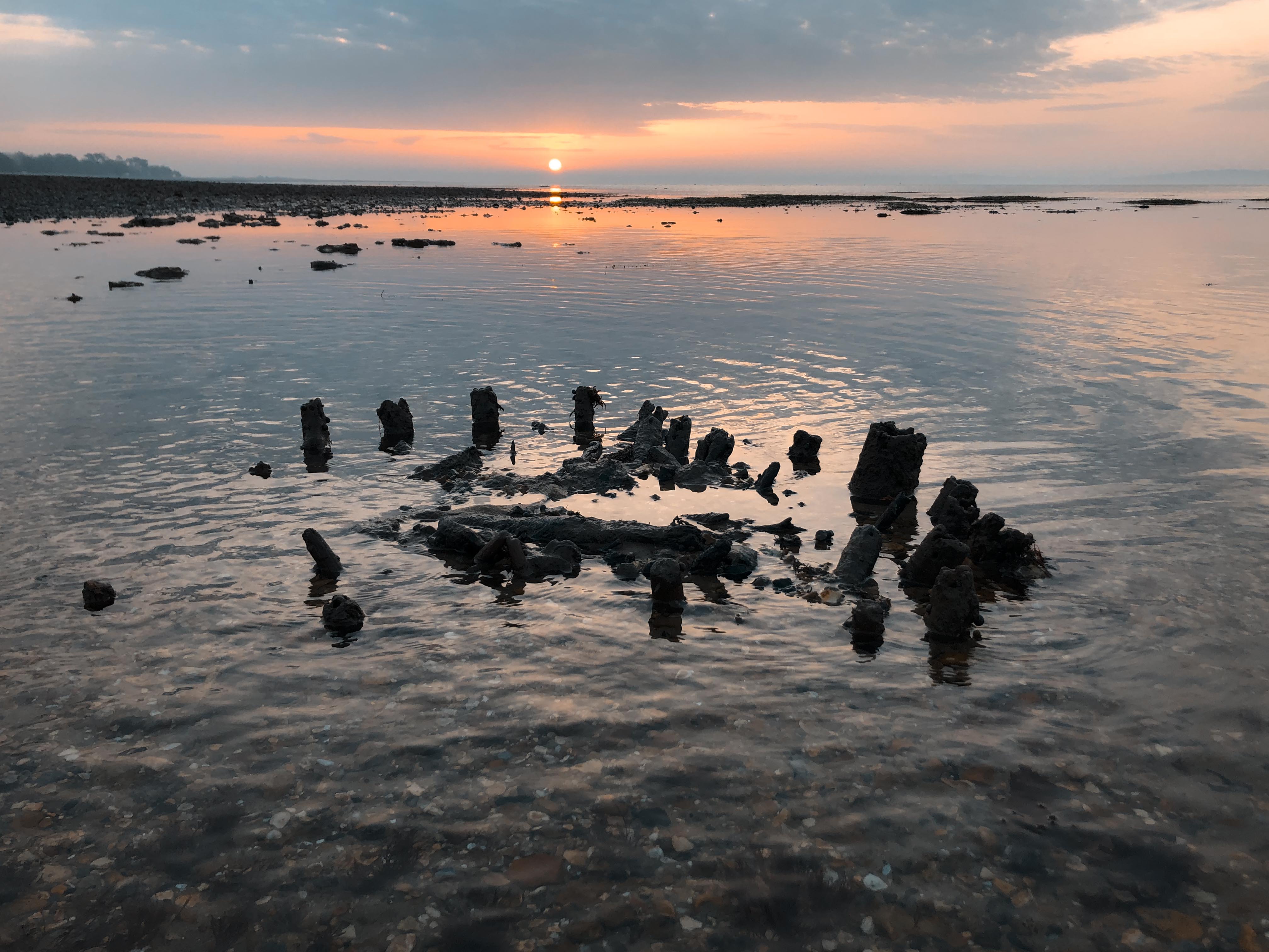
The underwater site at Bouldnor Cliff was occupied 8,000 years ago, shortly before the final
separation with mainland Europe. It has elements of a sedentary society that is 2,000 years ahead of
its time, including the discovery of the earliest evidence of wheat in the UK. These indications of
potential Neolithization are tantalizing but the discovery of boat building and evidence that
probably come from north of the Alps, demonstrate there was trade and mobility with people possibly
just passing through. However, if the shoots of sedentism were being sown at Bouldnor Cliff, it was
short lived before the sea covered the area, began to fill the Solent and formed open water between
Great Britain and the continent. Signs of settlement practices then disappear from the British
archaeological record but 2,000 years later the Neolithic arrives, and their remains are seen along
the north shores of the Solent where posts dated to 3346–2090 cal BC have been recovered next to a
palaeo-channel exiting the Beaulieu Estate. The remains of this structure are now almost 4m
underwater on a high spring tide, but when it was put in place, it would have been dry land by a
coastal stream and pollen evidence shows there was cultivation close at hand.
The people that lived in the area would have invariably taken advantage of the rich coastal
resources and by the Bronze Age we know they certainly did, as we have evidence in the form of a
basket dated to 1502–1401 cal BC, 500 metres west of the palaeo-channel in the same intertidal zone.
This is one of a number of Bronze Ages sites discovered in the last few years eroding from the
shoreline around the Solent, demonstrating there was a thriving Bronze Age maritime community in the
region.
 Bronze Age fish basket.
The coastal activity continued into the Roman period, where posts that formed the supports for a
tidal structure have also been found close to the old Beaulieu palaeo-channel. They dated to 255–416
cal AD. These new immaculately preserved discoveries can be used to calibrate past change. Each
fixed dateable structure holds a record of the changes that happened to and around it as time has
marched forward. We can learn about the pace and scale of sea level rise in the past and the changes
to the coastline today. Unfortunately, any site that is exposed is now under threat of loss and
where the site has been uncovered for the first time in millennia, it is clear that the stretch of
coastline within which it has remained buried, is also under threat of loss.
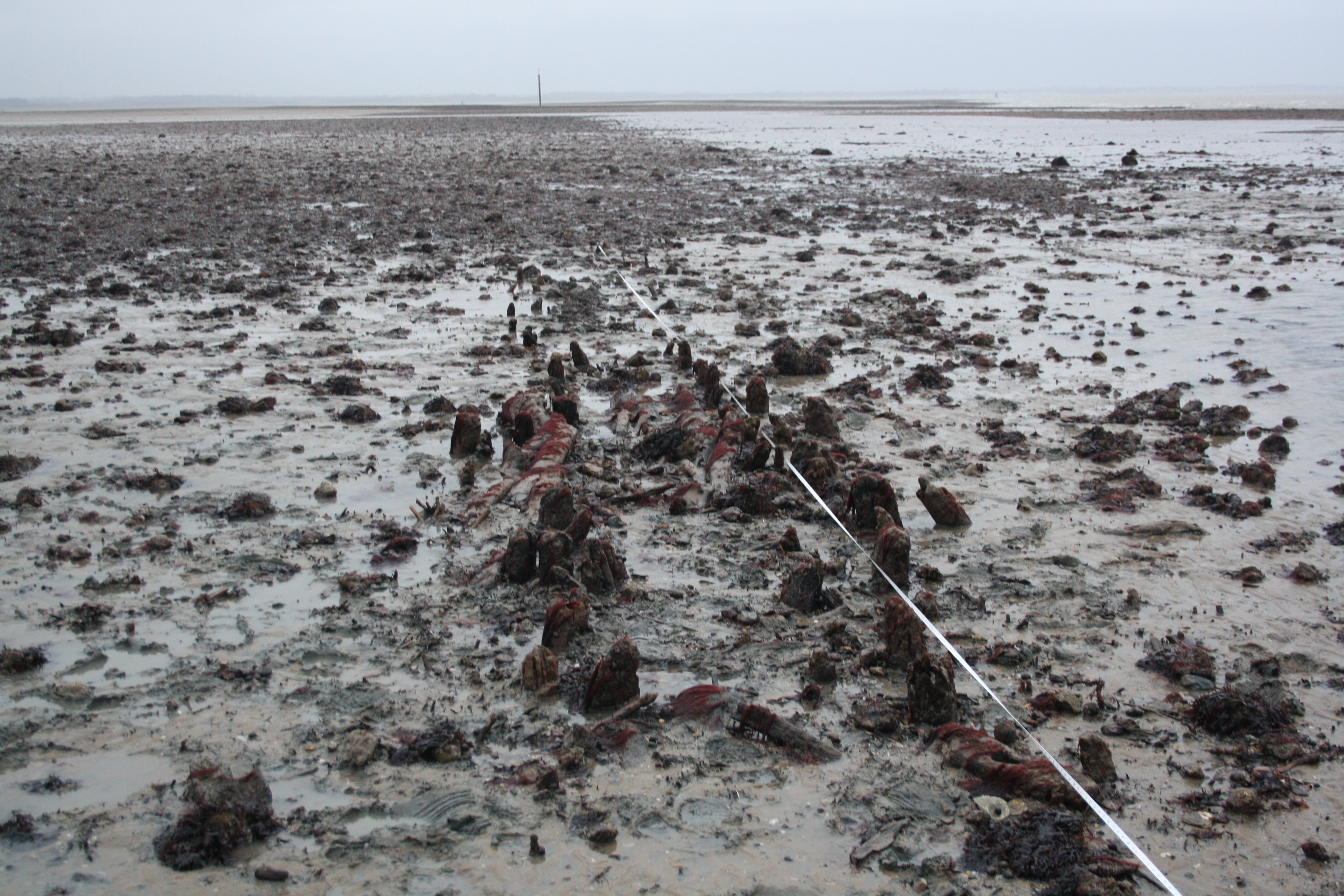 Roman posts at Beaulieu.